CHAPTER
Env-Wt 500 PROJECT-SPECIFIC REQUIREMENTS
Statutory Authority: RSA 482-A:11, I
REVISION NOTE #1:
Pursuant to a rules reorganization
plan approved by the Director of the Office of Legislative Services on
September 7, 2005, Department rules in Wt 500 filed under Document #8341,
effective 4-25-05, were editorially renumbered subsequently with subtitle Env-Wt
denoting the wetlands program area. The
title Wt was discontinued.
REVISION NOTE #2:
Document #12805, effective 12-15-19,
adopted, or readopted with amendment from other chapters, all of the rules in
Chapter Env-Wt 500, and changed the chapter heading from “Permit Procedure” to
“Project-Specific Requirements.”
Document #12805 reserved the Part
numbers Env-Wt 501 through Env-Wt 508 and adopted Env-Wt 509, Env-Wt 510,
Env-Wt 515, Env-Wt 517 through Env-Wt 520, Env-Wt 522, Env-Wt 523, and Env-Wt
525 through Env-Wt 527.
The provisions in the former Chapter
Env-Wt 500 specified procedures and criteria for applications for regular
permits, expedited minimum impact permits, permits by notification, seasonal
dock notifications, emergency permits, small motor mineral dredging permits,
and suspension, revocation, or modification of permits. These provisions were amended and moved by
Document #12803, effective 12-15-19, to Env-Wt 300.
Document #12805 established in Chapter
Env-Wt 500 project-specific criteria for activities for which approval under
RSA 482-A might be needed, including aquatic vegetation control; water access
structures (including beaches) (formerly in Env-Wt 304.08); breakwaters
(formerly in Env-Wt 402.07); docking structures and accessory docking
structures (formerly in Env-Wt 402.02-Env-Wt 402.06 and Env-Wt 402.08-Env-Wt
402.21); bank/shoreline stabilization; dug-in basins and boathouses; intake and
outflow structures; trails, pathways, and boardwalks; other nondocking
structures; ponds; forestry; utility projects (formerly in Env-Wt 304.13);
agricultural activities; non-tidal dredging; residential and commercial;
industrial development; restoration and enhancement activities; dams; and
public highways. The provisions in
Chapter Env-Wt 500 in Document #12805 apply primarily to non-tidal areas,
although some sections were incorporated by reference into Env-Wt 600 on tidal
areas by Document #12806, effective 12-15-19.
Document #12805 replaces all prior
filings for rules in the former Chapters Wt 500 and Env-Wt 500.
#2271,
eff 1-10-83
#2924,
eff 12-11-84
#3076,
eff 7-26-85
#4806,
eff 4-27-90
#5028,
eff 12-20-90
#5401,
INTERIM, eff 5-21-92, EXPIRED 9-18-92
#5550,
eff 1-5-93
#5904,
eff 9-30-94
#6219,
eff 4-4-96
#6404,
INTERIM, eff 12-21-96, EXPIRED 4-20-97
#6429,
eff 1-18-97, INTERIM
#6498-B,
eff 4-23-97
#7048,
eff 6-29-99
#7158,
eff 12-17-99
#7896,
eff 5-22-03
#7988,
eff 11-21-03
#8062,
eff 3-13-04
#8165,
eff 9-10-04
#8341,
eff 4-25-05
The
prior fillings for former Chapter Env-Wt 500 after Document #8341 were
effective 4-25-05 included the following documents:
#8911,
eff 6-20-07
#9717,
eff 5-25-10
#10367,
eff 6-26-13
PART Env-Wt 501 - RESERVED
PART Env-Wt 502 - RESERVED
PART Env-Wt 503 - RESERVED
PART Env-Wt 504 - RESERVED
PART Env-Wt 505 - RESERVED
PART Env-Wt 506 - RESERVED
PART Env-Wt 507 - RESERVED
PART Env-Wt 508 - RESERVED
PART
Env-Wt 509 PURPOSE; APPLICABILITY;
ABBREVIATIONS AND ACRONYMS
Env-Wt 509.01 Purpose. The purpose of this chapter is to establish
clear project-specific requirements so that persons proposing projects in
jurisdictional areas will know in advance what requirements apply.
Source. #12805, eff 12-15-19
Env-Wt 509.02 Applicability.
(a) This chapter shall apply as specified in
Env-Wt 305.02, provided that “this chapter” shall mean Env-Wt 500.
(b) Except as provided for boardwalks,
restoration/enhancement, and public roadways, this chapter shall apply to
projects in areas that are not coastal areas, which are subject to Env-Wt 600.
(c) Projects not specifically listed shall be
subject to all qualifying criteria established in:
(1) RSA 482-A
and RSA 483-B; and
(2) Env-Wt 300, Env-Wt 400, and
Env-Wt 600 through Env-Wt 900.
Source. #12805, eff 12-15-19
Env-Wt 509.03 Abbreviations and Acronyms. Abbreviations and acronyms used throughout
this chapter shall have the meaning assigned in Env-Wt 100, as summarized in
Appendix E.
Source. #12805, eff 12-15-19
PART
Env-Wt 510 AQUATIC
VEGETATION CONTROL
Env-Wt 510.01 Applicability.
(a)
This part shall apply to projects for the removal of native aquatic
vegetation (NAV) and exotic aquatic weeds (EAW), as defined in RSA 487:16 and
reprinted in Appendix C, and Env-Wq 1302.06, that:
(1) Do not
qualify for a conditional exemption under Env-Wt 309.02(c); and
(2) Are
required for continued access to a legally established navigable frontage
associated with an inland waterbody.
(b)
This part shall not apply to those projects that require removal or
disturbance of the underlying substrate that would constitute dredging covered
under Env-Wt 523.
Source. #12805, eff 12-15-19
Env-Wt 510.02 Approval Criteria for EAW Control Projects. In addition to meeting the applicable
conditions established in Env-Wt 300, and subject to Env-Wt 510.03, the
department shall not approve a project to remove or otherwise control EAW
unless the following criteria are met:
(a) The project is conducted in accordance with a
long-term management plan designed pursuant to Env-Wq 1305.03;
(b)
In flowing waters, harvesting is initiated only at the most upstream
location of the infestation, where practicable;
(c)
The vegetation control is done in a manner that avoids impacts that
would be deleterious to fish and wildlife habitat or cause degradation of water
quality;
(d)
The project:
(1) Minimizes
the removal of NAV where such vegetation provides:
a. Spawning,
nursery, or nesting habitat for fish, zooplankton, macroinvertebrates, fish, or
waterfowl; or
b. Food for
zooplankton, macroinvertebrates, fish, waterfowl, moose, and other
water-dependent species;
(2) Complies
with RSA 487:15 through 25, the New Hampshire Clean Lakes Program; and
(3) Uses a
construction sequence that minimizes impacts to any adjacent PRAs;
(e)
The project is not located in:
(1) A PRA,
except as provided in Env-Wt 407; or
(2) A diverse
habitat that provides nesting or foraging habitat for fish or wildlife that
would be negatively impacted by vegetation removal; and
(f)
All vegetation removed will be disposed of outside of jurisdictional
areas using an acceptable means of disposal as listed in Env-Wq 1303.06.
Source. #12805, eff 12-15-19; amd by #13124, eff
10-23-20
Env-Wt 510.03 Hand Removal of EAW Without a Permit. No permit shall be required for hand removal
of EAW or the installation and maintenance of benthic barriers on the bottom of
a surface water to control the growth of EAW, as authorized by RSA 487:17,
provided:
(a)
The work is conducted by divers who have received training in EAW
control diving from a diving instructor that is registered and confirmed with
the department’s invasive species coordinator;
(b)
The project is conducted in accordance with a long-term management plan
designed pursuant
to
Env-Wq 1305.03;
(c)
The project is not located in a PRA;
(d)
In flowing waters, harvesting will be initiated only at the most
upstream location of the infestation, where practicable; and
(e) The project does
not qualify as a major project under Env-Wt 400.
Source. #12805, eff 12-15-19
Env-Wt 510.04 Approval Criteria for NAV Removal Projects. In addition to meeting the applicable
conditions established in Env-Wt 300, the department shall not approve a
project to control or eradicate NAV unless the following criteria are met:
(a)
The project:
(1) Is
necessary to maintain access to an existing legal beach, docking facility,
public boat ramp, or community swim area because the NAV is:
a. Negatively
affecting private or public access to the waterbody;
b.
Interfering with the applicant’s ability to reasonably use watercraft or
to engage in other recreational uses; or
c.
Interfering with the normal outflow or flushing of the waterbody;
(2) Minimizes
potential water quality impacts where disturbance to soft bottom substrates
could result in turbidity or changes to the cross-section of the bottom if
aquatic plants are disturbed or removed; and
(3) Protects
critical habitats, nesting sites, and spawning fishery locations; and
(b) The project will not:
(1) Remove a
protected species or habitat;
(2) Remove or
disturb root systems or substrate materials or grades that would constitute
dredging;
(3) Be
located in:
a. A PRA, except as provided in
Env-Wt 407; or
b. A diverse habitat that provides
nesting or foraging habitat for fish or wildlife that would be negatively
impacted by the removal of vegetation; or
(4) Cause
removal of NAV that is part of a floating island.
Source. #12805, eff 12-15-19; amd by #13124, eff
10-23-20
Env-Wt 510.05 Application Requirements for NAV Removal
and EAW Control Projects.
(a)
For projects to remove NAV or to remove or otherwise control EAW that
are not exempt under Env-Wt 510.03, the project-specific information required
by Env-Wt 310.01(c)(1) or Env-Wt 311.03(b)(11), as applicable, shall be as
follows:
(1) A brief
summary of the proposed project, including:
a. A concise statement of what the
project is intended to accomplish;
b. A list of each task to be
undertaken as part of the project and for each, who will do it and how it will
be done;
c. The location of the proposed
project and the name of each owner of property adjacent to the project;
d. The proposed start date and end
date of the project;
e. A description of each target
plant species for removal; and
f. An estimate of the total
footprint area in square feet (SF) and volume of vegetation in cubic yards (CY)
to be removed and non-target species in the vicinity;
(2) For any
EAW removal project proposing more than 10,000 SF in surface area, more than 5%
of the surface area of a waterbody, or any impact to a PRA, an aquatic
vegetation management plan for the impacted area of the lake or pond that:
a. Addresses long-term and
cumulative impacts from the proposed project; and
b. Identifies:
1. The functional value of the
vegetation to be removed; and
2. Known circumstances that caused
the increase in sediments or nutrients to the proposed impact area;
(3) A plan
showing the proposed areas for NAV or EAW removal, as applicable, with a
listing and annotation showing information on species abundance and coverage
including:
a. Description of plant species to
be removed and description of the plant community;
b. The extent of areal coverage;
c. The potential impact on native
plant communities, if applicable, and the distance of those native plant
communities from existing docking facilities;
d. Detailed dimensions showing the
existing vegetative cover and the proposed removal area of NAV or EAW removal;
and
e. The depth of removal;
a. Methods to contain, control,
and minimize water quality impacts;
b. Methods to transfer vegetation
that is removed without dispersing it;
c. Method(s) and location(s) for
dewatering removed vegetation;
d. Methods to minimize impacts to
fishery and wildlife habitats based on the time of year the project will occur;
and
e. Method of disposal of EAW,
consistent with Env-Wq 1303.06 relative to acceptable means of disposal;
and
(5) For
projects that propose mechanical harvesting of EAW from areas less than 2
meters deep, equivalent to 6.6 feet deep, or for which an aquatic vegetation
management plan is required by (2), above, a wetland delineation, wetland
assessment, and characterization of emergent aquatic bed wetlands.
(b)
The applicant shall provide copies of the plan required by (a)(2) to the
local lake association and conservation commission(s).
Source. #12805, eff 12-15-19; amd by 13124, eff
10-23-20
Env-Wt 510.06 Design Requirements for EAW Control
Projects. In addition to meeting
applicable design requirements established in Env-Wt 307, a proposed project to
remove or otherwise control EAW shall be:
(a)
Designed to comply with all applicable requirements of RSA 487 and
Env-Wq 1300; and
(b)
Developed in consultation with the department’s invasive species
coordinator and watershed bureau.
Source. #12805, eff 12-15-19
Env-Wt 510.07 Construction Requirements for NAV Removal
and EAW Control Projects. In
addition to meeting all applicable construction standards specified in Env-Wt
307, the following shall apply to projects to remove NAV and to remove or
otherwise control EAW:
(a) The project shall be supervised by:
(1) A certified wetland scientist;
or
(2) For EAW control projects, a certified wetland
scientist having experience in identifying and controlling EAW;
(b) Where protected species or habitat has been
identified, the permittee shall coordinate with the ecological review section
of the department pursuant to Env-C 800;
(c) For EAW control projects, all reasonable
precautions shall be taken within riparian areas to prevent unnecessary removal
of native vegetation during access to and transfer of removed EAW;
(d) Any riparian area in which native vegetation
that is not the target vegetation of the project has been damaged or removed
shall be revegetated with like native species within 3 days of the completion
of the disturbance;
(e) Upland and bank areas landward of the project
area shall not be disturbed by regrading or filling;
(f) All persons undertaking the work shall take
precautions in accordance with Invasive Plant BMPs, available as noted in
Appendix B, to prevent the import or transport of seed stock containing
nuisance or invasive species such as Purple Loosestrife, Knotweed, and
Phragmites; and
(g) Within 60 days of final site stabilization,
the permittee shall submit a follow-up report to the department that includes a
summary of the project and photographs of all stages of construction.
Source. #12805, eff 12-15-19; ss by #14349, INTERIM,
eff 8-26-25; ss by #14471, eff 1-2-26, EXPIRES: 1-2-36
Env-Wt 510.08 Classification
of NAV Removal and EAW Control Projects.
Except for hand removal of EAW pursuant to Env-Wt 510.03, projects to
remove NAV or control EAW that do not qualify for an LSA under Env-Wt 309.01(b)
shall be classified as follows:
(a) An aquatic
vegetation control project shall be classified as a minimum impact project if:
(1) The
project is not located in a PRA;
(2) The
project is not located in a watercourse;
(3) If an EAW
project, the maximum area disturbed does not exceed one acre in area; and
(4) If a NAV
project:
a. The
maximum area disturbed does not exceed 1,000 SF with a maximum width of 15
feet; and
b. The
project is associated with navigable non-tidal waterfront property and is
required to continue access to an existing legal beach, docking facility, swim
area, or community launch area;
(b)
An aquatic vegetation control project shall be classified as minor
impact if the project exceeds any of the criteria or conditions specified in
(a), above, and:
(1) If a NAV
project, the maximum area of disturbance is less than 10,000 SF; or
(2) If an EAW
project, the maximum area of disturbance is less than 5 acres; and
(c) An aquatic
vegetation control project shall be classified as major impact if the project
exceeds any of the minimum impact criteria in (a), above, and:
(1) If a NAV
project, the maximum area of disturbance is 10,000 SF or greater; or
(2) If an EAW project, the maximum area of
disturbance is 5 acres or greater.
Source. #12805, eff 12-15-19
PART Env-Wt 511 CONSTRUCTION OF WATER ACCESS STRUCTURES AND BEACH
REPLENISHMENT
Env-Wt 511.01 Applicability; Definitions.
(a)
This part shall apply to any person who wishes to:
(1) Construct
or expand any combination of water access structures;
(2) Replenish
a beach; or
(3) Repair,
replace, or maintain an existing legal water access structure.
(b) The following definitions shall apply to this
part:
(1) “Stairs”
means a structure made from wood or a wood substitute that is constructed over
the surface of a bank to facilitate moving between different levels; and
(2) “Steps”
means a structure made from stone, concrete, or similar materials that is dug
into a bank to facilitate moving between different levels.
Source. #12805, eff 12-15-19; amd by 12954, eff
12-24-19
Env-Wt
511.02 Approval Criteria for Water
Access Structures. In addition to
meeting the applicable conditions established in Env-Wt 300, the department
shall not approve an application to construct or install a water access
structure unless the following criteria are met:
(a) The
project is not listed as a prohibited activity in Env-Wt 306; and
(b) The
applicant demonstrates that:
(1) The water access structure will not
contribute sand or sediment to the adjacent surface water;
(2) Any new water access structure, exclusive of
any associated stairs, shall not impact a wetland, watercourse, or bank of a
watercourse; and
(3) Any new water access structure, or
modification of an existing structure, proposed within protected shorelands
will comply with RSA 483-B and Env-Wq 1400.
Source. #12805, eff 12-15-19; amd by #13124, eff
10-23-20; ss by #13776, eff 10-13-23
Env-Wt
511.03 Water Access Structure
Project-Specific Application Requirements.
The following project-specific information shall be provided on the plans submitted for all applications proposing impacts associated with a water access structure project, as applicable:
(a) The normal high water line;
(b) The limits of the bank(s);
(c) The amount of shoreline frontage for the
subject property;
(d) For a beach, the volume, in cubic yards, of
sand to be used;
(e) All temporary impact areas;
(f) Stormwater diversion methods to be used; and
(g) A cross section showing the following
information:
(1) The
difference in elevation between the lowest point of the shoreline slope to be
impacted by the structure and the highest point of the shoreline slope to be
impacted;
(2) The
linear distance across the proposed project area as measured along a straight
line between the lowest point of the shoreline slope to be impacted by the
structure and the highest point of the shoreline slope to be impacted;
(3) If a retaining wall is
proposed as part of the project:
a. The proposed height and width
of the wall to be constructed;
b. The type and materials of
construction; and
c. Any stormwater diversion
methods and drainage associated with the proposed wall; and
(4) Design
details and specifications of any pervious surface to be employed.
Source. #12805, eff 12-15-19; ss by #13776, eff
10-13-23
Env-Wt 511.04 Water Access Structure Design Requirements. In addition to meeting applicable design
requirements established in Env-Wt 307, the following design requirements shall
apply to water access structures:
(a) Wherever hardened shorelines exist, whether
due to naturally-occurring stones, installed rip-rap, or constructed retaining
walls, construction of a water access structure shall be landward and above the
hardened shoreline;
(b) Hardened shorelines shall remain intact with
the exception of material that must be removed for the installation of steps to
access the water;
(c) Where hardened shorelines do not exist,
water access surfaces shall be located at an elevation at least 12 inches
landward of the normal high water line;
(d) Beaches shall be designed such that the beach
surface has zero slope;
(e) All water access structures other than
beaches shall be sloped away from the adjacent surface water;
(f) Steps for access to and from a water access
structure shall:
(1) Not
exceed 6 feet in width; and
(2) Be
constructed or installed such that all portions of the steps are landward of
the normal high water line;
(g) Stairs constructed to and from a water access
structure shall:
(1) Not
exceed 6 feet in width; and
(2) If
installed or constructed to provide access to the water, be removed from the
lakebed prior to ice-in and not be re-installed until ice-out;
(h) Water access structures shall be located to
avoid and minimize removal of vegetation as required by RSA 483-B:9,V(a);
(j) No work shall be conducted in a wetland or
PRA, except as provided in Env-Wt 407;
(k) No new water access structures and no
combination of existing and proposed structures shall use more than 20 percent
of the applicant’s contiguous shoreline, up to a maximum of 50 feet; and
(l)
Appropriate devices for diversion of stormwater away from beaches shall
be installed immediately upslope of the beach.
Source. #12805, eff 12-15-19; amd by #12954, eff
12-24-19; amd by #13124, eff 10-23-20
Env-Wt 511.05 Water Access Structure Construction
Requirements. In addition to meeting
all applicable construction standards established in Env-Wt 300, the following
shall apply to water access structure projects:
(a) The water access structure shall be
constructed as shown in the approved plans and specifications;
(b) Revegetation of the disturbed area by
planting trees, shrubs, and ground covers shall:
(1) Represent
the density and species diversity of the existing stand of vegetation removed
for the project; and
(2) Begin at
a distance no greater than 5 feet landward from the water access structure’s
footprint; and
(c) Appropriate methods for the diversion of
stormwater away from the beach and deck shall be installed immediately upslope
of the structure.
Source. #12805, eff 12-15-19
Env-Wt 511.06 Water Access Structure Construction
Project Classifications.
(a)
Construction of a water access structure shall be a minimum impact
project only if all of the following criteria are met:
(1) No construction surface area, filling, or
dredging occurs below the normal high water line or ordinary high water mark,
as applicable;
(2) No work is done in a wetland or PRA, except
as provided in Env-Wt 407;
(3) The combination of existing and proposed water access structures
does not use more than 20 percent of the
applicant’s contiguous shoreline up to a maximum of 50 feet;
(4) A maximum of 10 CY of sand is used; and
(5) The total area impacted by water access structures does not exceed 250 SF.
(b) Construction of a beach shall be a minor
impact project if the project complies with (a)(1) through (4), above, and
either:
(1) The
project uses more than 10 CY of sand but not more than 20 CY of sand; or
(2) The
aggregate area impacted by water access structures is 250 SF or greater but
does not exceed 500 SF.
(c) Construction of a deck or patio shall be a
minor impact project if:
(1) The
project complies with (a)(1) through (4), above; and
(2) The
aggregate area impacted by water access structures is 250 SF or greater but
does not exceed 500 SF.
(d) Construction of a water access structure
shall be a major project if the project does not meet the criteria for a
minimum impact project specified in (a), above, or for a minor impact project
specified in (b) or (c), above.
Source. #12805, eff 12-15-19; amd by #12954, eff 12-24-19; amd by #13124, eff
10-23-20
Env-Wt 511.07 Beach Replenishment Project
Classifications.
(a) Replenishment of sand on an existing beach
shall be a minimum impact project only if all of the following criteria are
met:
(1) The
beach is an existing legal structure as defined in Env-Wt 102;
(2) No sand
is placed below the normal high water line or limits of flowage rights, as
applicable;
(3) No work
is done in a wetland, watercourse, or PRA, except as provided in Env-Wt 407;
(4) No more
than 10 CY of sand is used; and
(5) The
beach is not replenished more frequently than once in any 6-year period.
(b) Replenishment of a beach shall be a minor
impact project if the project meets the criteria in (a)(1)-(3), above, and
either:
(1) The
beach is replenished more frequently than once in a 6-year period; or
(2) More
than 10 CY of sand but not more than 20 CY of sand will be used.
(c) Replenishment
of an existing legal beach shall be a major impact project if the project does
not meet the criteria specified in (a) or (b), above.
(d) A beach that is not an existing legal
structure shall not be replenished unless an after-the-fact permit is obtained
for construction of the beach, which shall be classified as provided in Env-Wt
511.06.
Source. #12805, eff 12-15-19; ss by #13134, eff
10-23-20; ss by #13776, eff 10-13-23
Env-Wt
511.08 Deck or Patio Repair Project
Classifications.
(a) Repair of an existing deck or patio shall be
a minimum impact project only if all of the following criteria are met:
(1) The deck
or patio is an existing legal structure; and
(2) No work
is done in a wetland, watercourse, or PRA, except as provided in Env-Wt 407.
(b) Repair of an
existing deck or patio shall be a minor impact project if the criteria of (a),
above, are not met.
(c) A
deck or patio that is not an existing legal structure shall not be repaired unless an
after-the-fact permit is obtained for the construction of the structure, which
shall be classified as provided in Env-Wt 511.06.
Source. #12805, eff 12-15-19; amd by #12954, eff
12-24-19; ss by #13124, eff 10-23-20; ss by #13776, eff 10-13-23
PART Env-Wt
512 BREAKWATERS
Env-Wt 512.01 Applicability. This part shall apply to any person who
wishes to construct or maintain a breakwater.
Source. #12805, eff 12-15-19
Env-Wt 512.02 Approval Criteria for Breakwaters.
(a) In addition to meeting the applicable
conditions established in Env-Wt 300, the department shall not approve a
project to construct a breakwater unless the applicant establishes that:
(1) The
structure is proposed to be located in Lake Winnipesaukee;
(2) The
proposed site for the structure meets one of the criteria specified in (b),
below;
(3) The structure is located in an
area that:
a. Does not have accumulations of
sand, such as deltas or sand bars; and
b. Is not between 2 or more areas
where sand migrates from one area to another;
(4) The
property associated with the structure has 100 feet or more of shoreline
frontage;
(5) The
design of the structure meets all design criteria specified in Env-Wt 512.04;
(6) The
application for the structure contains the additional information specified in
Env-Wt 512.03; and
(7) The
structure will be constructed as specified in Env-Wt 512.05.
(b) To qualify for a breakwater, the applicant
shall demonstrate, as specified in (c) or (d), below, as applicable, that the
site for the proposed structure is exposed to:
(1) A single
radial fetch of at least 4 miles between compass headings 300 and 330 degrees
as measured from true north; or
(2) Waves
that are at least 2 feet high, measured from trough to crest, in water at least
3 feet deep, on at least 4 separate occasions, lasting at least 4 hours each,
between May 15 and October 15 of the same year.
(c) To demonstrate that the site meets the
criterion specified in (b)(1), above, the applicant shall provide a copy of the
map of Lake Winnipesaukee found in Appendix D, which shows areas that meet the
location requirements, with the location of the proposed structure marked
clearly. In lieu of a copy of the map in
Appendix D, the applicant may provide a portion of a larger copy of the map
obtained from the department or the department’s website.
(d) To demonstrate that the site meets the
criterion specified in (b)(2), above, the applicant shall provide either:
(1) Dated
photographs or video recording and a summary of the wave heights measured, the
dates measured, and the frequency of measurement during each 4-hour period,
which frequency shall be sufficient to show, in conjunction with the
photographs, that the wave activity is essentially continuous throughout each
4-hour period; or
(2) Written
site measurements and photographs completed during the relevant period and
supported by a scientifically-accepted wave propagation model using regional
wind data.
Source. #12805, eff 12-15-19
Env-Wt
512.03 Application Requirements for
Breakwaters.
(a) The project-specific information required by
Env-Wt 311.03(b)(11) for a breakwater application shall be as specified in (b)
and (c), below.
(b) The following information shall be shown on
the plan required by Env-Wt 311.03(b)(4):
(1)
Dimensions of the structure, including dimensions at the toe of slope;
(2) The
dimensions visible at normal high water level;
(3) The
direction of prevailing wave activity;
(4) A line
representing the 50-foot distance from the shoreline within which a breakwater
may be constructed pursuant to Env-Wt 512.04(e)(1);
(5) All
docking structures on the subject property or otherwise associated with the
subject property; and
(6) The
construction sequence that will be followed.
(c)
The applicant also shall provide:
(1)
Cross-sections showing the height and slope of the structure and the
normal high water line; and
(2) A complete list of all
construction materials.
Source. #12805, eff 12-15-19
Env-Wt 512.04 Breakwater Design
Requirements. In addition to meeting all applicable design requirements
established in Env-Wt 300, the following design requirements shall apply to
breakwaters:
(a) The height of the breakwater shall not exceed
3 feet above the normal high water line;
(b) The width of the breakwater at its highest
point shall not exceed 3 feet;
(c) The side slopes of the breakwater shall be
1:1.5, rise to run, or steeper;
(d) The sides and top of the breakwater shall
have irregular surfaces to diffuse wave activity;
(e) The breakwater, when measured from the normal
high
water line, shall have:
(1) No point
more than 50 feet from the normal high water line;
(2) A total
length of no more than 70 feet; and
(3) A gap of
6 feet or more between the breakwater and shoreline;
(f) The proposed configuration for the breakwater
shall be the least impacting option available for breakwater construction for
that site;
(g) No portion of the breakwater, including any
portion underwater, shall be placed within 20 feet of an abutting property line
or its imaginary extension into the water; and
(h) The breakwater shall be constructed of stone,
concrete, wood, or other inert materials, consistent with the individual
conditions of each site.
Source. #12805, eff 12-15-19
Env-Wt 512.05 Breakwater Construction Requirements.
In addition to meeting all applicable construction standards established in
Env-Wt 307, the following shall apply to breakwater construction projects:
(a) The breakwater shall be constructed as shown
in the approved plans and specifications;
(b) No rocks shall be stockpiled in any
jurisdictional area unless the applicant:
(1)
Specifically requests authorization for such stockpiling in the
application and receives such authorization in the permit; and
(2) Documents
in the application that the limited and difficult access to the site precludes
stockpiling outside of jurisdictional areas;
(c)
Any rocks stockpiled in jurisdictional areas shall be removed:
(1) As soon
as practicable; and
(2) In every
case, by the conclusion of construction on the breakwater; and
(d) Rocks from the frontage of the subject
property shall be used as a source of breakwater material only if:
(1) The
applicant specifically requests authorization for such use in the application
and receives such authorization in the permit; and
(2) The rocks
are removed from another structure on the frontage for the purpose of
constructing the breakwater and are not dug or blasted out of the ground.
Source. #12805, eff 12-15-19
Env-Wt 512.06 Breakwater Construction Project
Classification.
(a) Breakwater construction shall be a major
project, regardless of the size of the breakwater.
(b) Classification as a major project pursuant to
(a), above, shall:
(1) Take
precedence over any lower classification; and
(2) Not be
subject to a waiver.
Source. #12805, eff 12-15-19
Env-Wt 512.07 Breakwater Maintenance and Repair Project
Classification.
(a) A breakwater may be maintained or repaired
without obtaining a permit only if all of the following conditions are met:
(1) The
breakwater was originally constructed prior to permit jurisdiction or was
installed pursuant to a permit and in compliance with all permit terms and
conditions;
(2) The work
consists only of placing materials that have been dislodged from the breakwater
back into their original location; and
(3) All work
is done without the use of machinery.
(b) Breakwater maintenance and repair shall be a
minimum impact project only if both of the following conditions are met:
(1) The
breakwater was originally constructed prior to permit jurisdiction or was
installed pursuant to a permit and in compliance with all permit terms and
conditions; and
(2) The work
consists of replacement of original materials that have been dislodged from the
breakwater into their original location using machinery that will be operated
from a barge or from a land area outside of any jurisdictional areas.
Source. #12805, eff 12-15-19; ss by #13776, eff
10-13-23
Env-Wt 512.08 Required Modification or Removal of
Breakwaters.
(a) Subject to (b), below, the owner of a
breakwater that causes significant adverse effects on abutting property owners
or on public use of the water, such as by creating or contributing to the
formation of sand bars or other navigation hazards, shall modify the breakwater
so as to eliminate such adverse effects.
(b) The owner of the breakwater shall remove the breakwater if:
(1) Modification
is not practicable; or
(2) The
modification is ineffective in eliminating the adverse effects.
(c) No modification or removal shall be
performed without first obtaining a permit for the modification or removal
under RSA 482-A.
(d) The removal of a breakwater shall be classified as a minor project.
(e) The modification of a breakwater shall be
classified as a major project.
Source. #12805, eff 12-15-19;
ss by #13776, eff 10-13-23
PART Env-Wt 513 DOCKING STRUCTURES AND ACCESSORY DOCKING STRUCTURES
Env-Wt
513.01 Purpose. The purpose of this part is to establish
standards for all docking structures, except those that qualify for the permit
exemption established in RSA 482-A:3, IV-a.
In order to minimize congestion, improve public safety and navigation,
protect neighboring property values, provide sufficient area for construction
of docking structures, ensure adequate area for boat maneuvering, and protect
health, safety, and general welfare, all docking structure design
shall minimize construction surface area, utilize the
clustering or merging of docking structures, and minimize impacts to the banks
associated with docking structures.
Source. #12805, eff 12-15-19; ss by #13776, eff
10-13-23
(a) Subject to (b), below, this part shall apply to the construction,
modification, repair, or replacement of docking structures, including accessory
docking structures.
(b) This part shall
not apply to:
(1) Maintenance and repairs undertaken pursuant to the statutory exemption described in
Env-Wt 308.01;
(2) Temporary seasonal docks
installed pursuant to RSA 482-A:3, IV-a(a) and the repair in kind of docking
structures registered in accordance with RSA 482-A:3, IV-a(b) and Env-Wt 1000;
(3) Swim rafts or moorings installed in
accordance with applicable state law and rules adopted by the New Hampshire
department of safety;
(4) Aquatherms, circulators, and
similar devices for the
prevention of ice formation
around structures that have
been installed in accordance
with state law
and rules adopted
by the
New
Hampshire department of safety;
(5) Devices attached solely to the sides
or
surfaces of a docking structure for the purpose of securing
lines for existing boat slips, such as cleats,
whips, or tie-posts; and
(6) Diving boards, slides,
and ladders that are
not a navigational hazard.
Source. #12805, eff
12-15-19; amd by #13124, eff 10-23-20; ss by #13776, eff 10-13-23
Env-Wt 513.03 Approval
Criteria for Docking Structures. In addition to meeting the applicable
approval criteria in Env-Wt 300, the department shall not approve
an application for the
construction or modification of any docking structure or accessory docking structure, unless the applicant demonstrates that the following
criteria are met:
(a) The structure
will not unreasonably affect the following:
(1) The ability of abutting owners to
use and enjoy their properties; or
(2)
The public’s right to navigation, passage,
and use of the resource for commerce
and recreation;
(b) The structure
has been
designed, located, and configured to avoid impacts
to water quality, aquatic vegetation, and wildlife
and finfish
habitat;
(c) The structure
will not adversely
affect shoreline stability; and
(d) The type
of construction proposed is the least intrusive upon the
public trust that will ensure safe docking
on the frontage.
Source. #12805, eff 12-15-19; amd by #13124, eff
10-23-20; ss by #13776, eff 10-13-23
Env-Wt 513.04
Approval Criteria for Permanent Docking
Structures.
(a) In addition to meeting the conditions
established in Env-Wt 300, the department shall not approve
an application for
construction of any permanent
docking structure
or accessory docking structure,
unless the applicant establishes
that:
(1) The proposed permanent structure will be located
on a surface water body of over 1,000 acres;
and
(2) The proposed site for the structure is
exposed to a design fetch of at least 1 mile between compass headings 245 to 340 degrees, or a design fetch of
at least 2 miles between compass headings 341 to 0 or 0 to 244 degrees, as
measured from true north.
(b) When
the applicant does not meet the requirements of (a)(2), above, the department
shall approve permanent docking or accessory docking structures, provided the
applicant documents the occurrence of waves of at least one foot in height
measured from trough to crest in water at least 3 feet deep, at the location of
the proposed structure on at least 4 separate occasions, lasting 4 hours each,
between the dates of May 15 and October 15.
(c) To qualify under (b), above, the applicant
shall provide the following:
(1) Dated photographs and a summary of the wave heights measured, the dates measured,
and the frequency of measurement during the 4-hour periods; or
(2) Written site measurements completed during
the relevant period and verified as accurate by the department.
(d) The
frequency of wave height measurements shall be high enough to show, in
conjunction with the pictures, that the wave activity is essentially continuous
throughout the 4-hour periods.
(e) A
permanent docking or accessory docking structure shall be
approved regardless of the design fetch when at least one of the following
criteria is met:
(1) The structure will be located on an island
accessible only by watercraft;
(2) The structure will be subjected to unusually
heavy loading where a permanent structure is needed for safety, such as a
structure at a commercial facility that is used to convey heavy equipment or
freight; or
(3) The structure will provide a significant
public benefit, such as a docking facility that is open to the general public
for transient use.
Source. #12805, eff
12-15-19; amd by #12954, eff 12-24-19; amd by #13124, eff 10-23-20; ss by
#13776, eff 10-13-23
Env-Wt 513.05 Approval Criteria
for Accessory Docking
Structures. In
addition to the criteria and requirements established for docking structures,
the construction, installation, or modification
of an accessory docking structure,
whether an anchoring
pad for a seasonal
docking structure, canopy, dolphin, ice cluster, tie-off piling,
wave attenuator, or watercraft lift, shall comply with the applicable
provisions of this part relative to design
and construction standards
for specific types of accessory
docking structures.
Source. #12805, eff 12-15-19; ss by #13124, eff
10-23-20; ss by #13776, eff 10-13-23
(a) On the drawing required by Env-Wt 310.01 or the plan required by Env-Wt 311.03(b)(4), the following:
(1) The normal high water
line for projects on a lake, pond,
or marsh;
(2) The ordinary high water mark for projects on
a watercourse;
(3) The amount of shoreline frontage
for
the subject property;
(4) The general
shape of the shoreline including the length of frontage;
(5) The footprint
of all existing
and proposed structures within jurisdiction along the
property frontage;
(6) The structural supports for all existing and proposed structures;
(7) The distance
from existing and proposed work to abutting property
lines; and
(8) A cross section
showing the proposed
height, width, and
location of any concrete pad associated
with the docking
structure construction relative
to either:
a. The normal high water line for lakes and
ponds; or
b. The ordinary high
water mark for watercourses; and
(b) Any applicant who wants a
longer docking structure than is
specified in Env-Wt 513.11(a)
shall submit all information needed to show that
the project meets
one of the criteria
in Env-Wt 513.08.
Source. #12805, eff 12-15-19; amd by #13124, eff
10-23-20; ss by #13776, eff 10-13-23
Env-Wt
513.07 Municipal
Review of Public or Commercial Docking Structures or Marinas.
(a) The applicant for a permit to construct
a new public or commercial docking structure
or
marina or to expand an existing legal public
or commercial docking structure
or
marina shall:
(1) Certify that the proposed new or expanded structure,
as applicable,
complies with all applicable local requirements; and
(2) Provide documentation to support the
certification.
(b) Subject to (c) and
(d), below, the documentation required
by (a)(2), above, shall be:
(1) A copy of the local permit or approval; or
(2) A letter
from the applicable local land use
board or local governing
body indicating that a permit or approval is
not
required under local regulations.
(c) If local approval is required
but has not been
issued at the time
the application is filed with the department, the applicant shall certify that the local application has been filed but a decision
has not yet been issued.
(d)
Local regulations shall not restrict
the sole and exclusive authority of the state to authorize
construction over, or dredge
and fill in, great ponds
or public-owned
water bodies. If a municipality denies the local application or does not act on the application in a timely manner, the applicant may request
a waiver of the requirement of (a), above,
in accordance with Env-Wt 204.
Source. #12805, eff 12-15-19; amd by #13124, eff
10-23-20
Env-Wt 513.08 Exceptions to Dimensions. If an applicant wants a docking structure
having dimensions greater than those specified in Env-Wt 513.11(a), the
applicant shall provide information demonstrating that one or more of the
following is true:
(a) Conforming to the specified size would represent a safety hazard due
to wind or other typical weather conditions;
(b) The property
has a unique physical
characteristic that requires
a greater
length that is not shared generally by nearby properties, such as insufficient water depth;
(c) If the application is for a public docking structure,
the
number of people or volume
of cargo,
or both, that is
anticipated for the docking
structure necessitates
larger dimensions; or
(d) Clustering or merging
the docking structures in one
location would result in less environmental impact to the shoreline and water body than
would standard dimensions and installation.
Source. #12805, eff 12-15-19; amd by #13124, eff
10-23-20; ss by #13776, eff 10-13-23
Env-Wt
513.09 Design
Requirements for Docking Structures.
In addition to meeting the
applicable application requirements of Env-Wt 300, all docking
structures shall meet the applicable requirements specified in Env-Wt 513.10,
Env-Wt 513.11, Env-Wt 513.14, and Env-Wt 513.22.
Source. #12805, eff 12-15-19
Env-Wt 513.10 Setback
Requirements for Docking Structures.
(a) All
docking structures and accessory docking structures shall be located at least
20 feet from an abutting property line as required by RSA 482-A:3, XIII(a).
(b) Any request to locate a docking structure closer than
20 feet from an abutter’s property line shall include signed and notarized
written consent from the affected abutters as specified in RSA 482-A:3,
XIII(c),
(c) Any request submitted jointly by abutters for a common
docking structure on or near their common property line shall include a
notarized written agreement signed by all property owners which shall be, upon
issuance of a permit, filed at the registry of deeds and attached to the deed
of each property owner as specified in RSA 482-A:3, XIII(d).
(d) Pursuant
to RSA 482-A:3, XIII(b), and as clarified by (e), below:
(1) Docking
structures may be perpendicular or parallel to the shoreline or extend at some
other angle into a water body, depending on the needs of the landowners,
factors related to safe navigation, and the difficulty of construction; and
(2) Any boat secured to
such a docking structure shall not extend beyond the extension of the abutter's
property line.
(e) In order to maintain safe navigation, the standard
configuration for a docking structure in a watercourse shall be parallel to the
shoreline. If the applicant wishes to
have other than the standard configuration, the application shall include an
explanation of the reason(s) for the proposed alternative based on the factors
listed in (d)(1), above.
Source. #12805, eff 12-15-19; amd by #12954, eff
12-24-19; ss by #13776, eff 10-13-23
Env-Wt 513.11 Dimensions of Docking
Structures.
(a) Subject to (b), below, approvable standard
dimensions for a docking structure, including accessory docking structures,
shall not exceed the following dimensions:
(1) In lakes and ponds of
1,000 acres or more:
a. For seasonal docking structures, a deck width
of 6 feet and deck length of 40 feet, measured from normal high water mark; and
b. For permanent docking structures, a deck
width of 6 feet and deck length of 30 feet, measured from normal high water
mark;
(2) In lakes and ponds of
less than 1,000 acres, for all docking structures a deck width of 6 feet and
deck length of 30 feet, measured from normal high water mark; and
(3) In watercourses, for
seasonal docking structures a deck width of 6 feet and deck length of 40 feet,
measured along the shoreline.
(b) For
a property with less than 75 feet of water frontage, the docking structure
shall be no larger than 4 feet by 24 feet.
Source. #12805, eff 12-15-19; amd by #13124, eff
10-23-20; ss by #13776, eff 10-13-23
Env-Wt
513.12 Frontage Requirements for
Private and Non-Commercial Docking Structures.
(a) A property shall have a minimum of 75 feet of shoreline frontage to
construct a private and non-commercial docking structure with not more than 2
boat slips.
(b) An additional 75 feet of shoreline frontage
on the property shall be required for each additional boat slip or securing
location on a docking structure for private and non-commercial use.
Source. #12805, eff 12-15-19; amd by #13124, eff
10-23-20; ss by #13776, eff 10-13-23
Env-Wt 513.13 Concrete Pads
for Seasonal Docking Structures. Any
concrete pad installed to anchor a seasonal pier shall:
(a) Be
not more
than 7 feet wide
as measured along the shoreline;
(b) Not be in
prime wetlands or a duly-established
100-foot buffer;
(c)
Designed such that any adjacent
bank stabilization, such
as gravel or rip-rap,
will not cause the total impact of the pad to
exceed 10 LF along the bank;
(d)
For a concrete
pad on a pond or lake, be constructed landward
of
the normal high water line; and
(e) For a concrete pad on a watercourse, installed completely landward of the
ordinary high water line.
Source. #12805, eff 12-15-19
Env-Wt
513.14 Navigation
Space for Docking Structures. The
design and construction of docking structures shall allow for a maximum of 2
feet of navigation space between a boat slip and any other boat slip or
structure.
Source. #12805, eff 12-15-19
Env-Wt 513.15 Design
Requirements for Permanent Docking Structures.
(a) In
addition to meeting the applicable design requirements of Env-Wt 300, all permanent
docking structures and all accessory docking structures shall be designed to
meet the requirements in this part relative to setbacks, navigation space,
dimensions, and frontage, and the requirements of this section.
(b) The standard design for a permanent docking
structure shall be open pile construction.
(c) Pile bents shall be spaced at least 12 feet
apart, as measured from the center of each pile bent.
(d) The department shall approve a design other
than open pile construction only if the applicant demonstrates that:
(1) Pilings
cannot be driven due to site conditions; and
(2) The
alternate design proposed is the least impacting design for that location.
(e) The demonstration that pilings cannot be
driven shall:
(1) Be submitted with the
application; and
(2) Include documentation
of trial driving by commercial equipment, probings, or experience in
construction of immediately adjacent docks, or any combination thereof.
(f) If an applicant demonstrates that pilings
cannot be driven, an alternate design may be submitted.
(g) If the alternate design is a crib dock, the
crib shall be designed in accordance with the following:
(1) The
maximum size of the crib in water up to 6 feet deep shall not exceed 6 feet
long by 6 feet wide, and of such height as is necessary to support the deck
above the water level;
(2) The side dimensions of
the crib shall be increased by not more than one foot for every additional foot
of water depth above 6 feet;
(3) The
minimum clear spacing between cribs shall be not less than 12 feet; and
(4) The
crib itself shall be of timber, prefabricated concrete, or other approved
materials securely fastened together and of such size and spacing necessary to
completely contain the stone ballast or other fill material.
(h) If the alternate design is other than a crib dock, such as
caissons, concrete supports, or prefabricated cofferdams, the docking structure
shall be designed in accordance with standard engineering practices for the
design proposed.
Source. #12805, eff 12-15-19; amd by #13124, eff
10-23-20; ss by #13776, eff 10-13-23
Env-Wt 513.16 Additional
Design Standards and Application Requirements for Marinas.
(a) In addition to meeting all other applicable
requirements, a marina shall be designed to:
(1) Minimize its visual impact on abutters and
users of the surface water;
(2) Contain any leakage or spills of fuels,
lubricants, waste products, or other pollutants from all marina operations;
(3) Not represent a hazard to navigation;
(4) Have designated areas for washing or other
cleaning of watercraft;
(5) Control and treat storm water; and
(6) Include at least one pump-out facility for
the removal of wastes from on-board receptacles that receive and retain wastes
from toilets, sinks, showers, and other on-board sources of sewage or
graywater.
(b) On the plans
submitted with the application, the applicant shall show:
(1) The location and specifications of any
abrasive blasting, painting, or hull sanding operations;
(2) The locations and specifications of (a)(4)
through (6), above; and
(3) The location and method for disposing of used
oil and other waste products.
Source. #12805, eff 12-15-19
Env-Wt 513.17 Frontage
Requirements for Public or Commercial Docking Structures.
(a) The frontage standards established in this
section for public and commercial docking structures and marinas shall be for
the purpose of minimizing congestion, improving public safety and navigation,
protecting neighboring property values, providing sufficient area for
construction of docking structures, providing adequate area for boat
maneuvering, and protecting health, safety, and general welfare.
(b) Subject to (c) and (d), below, to support a
public or commercial docking structure or a marina, the subject property shall
have 25 feet of contiguous shoreline per boat slip.
(c) If the applicant wishes to have more than one
boat slip per 25 feet of frontage, the applicant shall request a waiver in
accordance with Env-Wt 203 that includes documentation that:
(1) The additional slips will not be contrary to
the purpose of the frontage requirement as specified in (a), above; and
(2) Allowing additional slips is in the public
interest, meaning that the benefit to the public of adding additional slips
outweighs the interests of the public in not causing additional adverse impacts
to jurisdictional areas, which shall not be established solely by documenting a
high demand for boat slips.
(d) If the department determines that allowing
one slip per 25 feet of contiguous frontage would pose a navigational hazard,
based on the configuration of the shoreline or the proximity of other
waterfront uses, or both, the department shall authorize fewer slips.
Source. #12805, eff 12-15-19
Source. #12805, eff 12-15-19; ss by #13776, eff
10-13-23; ss by #13776, eff 10-13-23
(a) The canopy shall not interfere
with boating safety by obstructing lines of sight necessary
to navigation;
(b) The
canopy, including the support frame and cover, shall be designed and
constructed to be readily removed at the end of the boating season;
(c) Installation
of a seasonal canopy shall not be justification for installation of a permanent
structure such as pilings, but existing legal permanent structures may be used
to support a seasonal canopy frame; and
(d) The canopy shall be
installed after ice-out and removed
prior to ice-in.
Source. #12805, eff
12-15-19; ss by #13776, eff 10-13-23
Env-Wt 513.20 Design and
Construction Requirements for Dolphins, Ice Clusters, and Tie-Off Piles. In
addition to meeting the applicable design and construction requirements of
Env-Wt 300, a dolphin, ice cluster, or tie-off pile shall be designed
and constructed so that the structure does not, by its presence alone or in
combination with similar proposed structures:
(a) Add boat slips to an existing docking
structure; or
(b) Present a hazard to navigation.
Source. #12805, eff
12-15-19; amd by #13124, eff 10-23-20
Env-Wt 513.21 Design and
Construction Requirements for Watercraft Lifts. In
addition to meeting the applicable design and construction requirements of
Env-Wt 300, a watercraft lift shall be designed and constructed in
accordance with the following:
(a)
Subject to (c), below, the lift shall be installed:
(1) In an
existing legal boat slip; or
(2) If a
personal watercraft lift, immediately adjacent to an existing legal docking
structure.
(b)
Any seasonal lift shall be installed, maintained, and removed in
accordance with Env-Wt 513.22(b); and
(c)
If a lift is the only structure on the frontage, it shall:
(1) Be
installed along the shoreline of the subject property; and
(2) Meet all
requirements for a seasonal docking structure specified in Env-Wt 513.22(b).
Source. #12805, eff
12-15-19; ss by #13124, eff 10-23-20
Env-Wt 513.22 Construction
and Maintenance of Docking Structures.
(a) Docking structures shall be constructed or
installed in accordance with the approved plans and specifications.
(b) All
seasonal docking structures shall be:
(1) Installed after ice-out and removed prior to
ice-in if on a lake or pond;
(2) Installed after May 15 and removed prior to
November 15 if on a watercourse;
(3) Placed in the water in a way that does not
obstruct navigation; and
(4) Removed from the water prior to applying any
paint, stain, or other preservative coating, and not returned to the water
until after such coating is dry.
(c) If
a permanent docking structure is not maintained so as to be usable for its
intended purpose, the owner of the subject property shall remove the docking
structure.
Source. #12805, eff
12-15-19; ss by #12976, ss by #13124, eff 10-23-20; ss by #13776, eff 10-13-23
Env-Wt 513.23 Modification of Existing Docking Structures.
(a) The
department shall not approve any change in size, location, or configuration of
an existing legal docking structure unless the applicant demonstrates, and the
department finds, that the modification:
(1) Is less environmentally-impacting than the
existing docking structure; or
(2) Provides for fewer boat slips and less deck
area over public submerged lands than the existing docking structure.
(b) The
addition of a permanent accessory docking structure to an existing legal
docking structure shall constitute a modification of the existing docking
structure.
(c) Modification
of a grandfathered docking structure that results in the same kind of structure
in the same or a more conforming location, having the same or smaller surface
area, and the same number or fewer boat slips, such that in all material
aspects the new structure is no more
impacting to the environment or abutting properties than the original
structure, shall not remove the structure’s grandfathered status.
Source. #12805, eff
12-15-19; ss by #13124, eff 10-23-20; ss by #13776, eff 10-13-23
Env-Wt 513.24 Docking
Structure Construction, Installation, or Modification Project Classifications.
(a) The construction, installation, or
modification of a docking structure, including accessory structures, shall be a
minimum impact project only if:
(1)
The project meets all of the following criteria:
a.
The proposed docking structure, including accessory structures, is
seasonal and meets all applicable criteria specified in Env-Wt 513.03, Env-Wt
513.10 through Env-Wt 513.12, Env-Wt 513.14, and Env-Wt 513.22;
b.
No more than 2 slips, including previously existing slips, are proposed;
c.
Any anchoring pad is designed and installed as specified in Env-Wt
513.13;
d.
Any watercraft lift is designed and installed as specified in Env-Wt
513.05 and Env-Wt 513.21; and
e.
Any proposed canopy meets the criteria of Env-Wt 513.26(a); or
(2) The project is limited
to the installation of seasonal watercraft lifts within legally existing boat
slips.
(b) The construction, installation, or
modification of a docking structure, including accessory structures, shall be a
minor project if the project does not meet the criteria specified in (a),
above, for minimum impact projects and:
(1)
No more than 4 boat slips, including previously existing boat slips, are
proposed;
(2)
The proposed docking structure, including accessory structures, will use
no more than 100 feet of waterfront; and
(3)
The structure is not regulated under Env-Wt 515.
(c) The construction, installation, or
modification of a docking structure, including accessory structures, shall be a
major project if:
(1)
The project does not meet the criteria for minimum impact projects
specified in (a), above, or for minor projects specified in (b), above;
(2)
The docking structure, including accessory structures, is a major
docking system; or
(3)
The docking structure, including accessory structures, is proposed to be
adjacent to or attached to a breakwater.
Source. #12805, eff 12-15-19; amd by 12976, eff
1-22-20; ss by #13124, eff 10-23-20; ss by #13124, eff 10-23-20; ss by
#13776, eff 10-13-23; ss by #14389, eff 9-25-25, EXPIRES: 9-25-35
Env-Wt 513.25 Docking Structure Repair or Replacement Project
Classifications. The in kind repair or replacement of an
existing legal docking structure, including any accessory structures, shall be
a minimum impact project.
Source. #12805, eff 12-15-19; ss by #13124, eff
10-23-20; ss by #13776, eff 10-13-23
Env-Wt 513.26 Canopy Project Classification.
(a) The
installation of a new canopy shall be a minimum impact project if:
(1) For surface waters 1,000 acres or larger,
the canopy measures a maximum of 14 feet by 30 feet and is the only canopy on
the frontage; or
(2) For surface waters smaller than 1,000 acres, the canopy
measures a maximum of 12 feet by 25 feet and is the only canopy on the
frontage.
(b) Any canopy project that exceeds the criteria
in (a), above, shall be classified based on the docking structure with which it
is associated or to which it is attached.
Source. #12805, eff 12-15-19; ss by #13124, eff
10-23-20; ss by #13776, eff 10-13-23 (formerly Env-Wt 513.27)
PART Env-Wt 514 BANK/SHORELINE STABILIZATION: ALL PROJECTS
Env-Wt 514.01 Purpose. The purpose of this part is to establish
requirements that apply to all types of bank and shoreline stabilization
projects, to maintain or restore healthy and vegetated bank and shoreline
system functions that will:
(a)
Hold soils together, stabilize banks and shorelines, and provide
structural erosion control;
(b)
Establish stable and sustainable ecosystems to provide high biological
diversity and complexity to support fish and wildlife habitats;
(c)
Ensure runoff filtering and effective sediment-trapping functions, so
that sediments settle out before nutrients and pollutants are carried into
surface waters; and
(d)
Provide flood abatement functions by trapping sediment during floods and
slowing velocity of floodwaters.
Source. #12805, eff 12-15-19
Env-Wt 514.02 Approval Criteria for All Bank/Shoreline
Stabilization Projects.
(a) In addition to meeting the applicable conditions established in
Env-Wt 300, the department shall not approve a hard-scape stabilization
proposal such as rip-rap or a retaining wall unless the applicant demonstrates
that the bank or shoreline in that location cannot be stabilized by preserving
or restoring natural vegetation, landscaping, or bioengineering.
(b)
Bank/shoreline stabilization shall:
(1) Be
designed to be the least intrusive practicable method in accordance with
Chapter 8 of the A/M BMPs, available as noted in Appendix B;
(2) Conform
to the natural alignment of the bank/shoreline;
(3) Not
adversely affect the stream course such that water flow will be transported by
the stream channel in a manner that the stream maintains its dimensions,
general pattern, and slope with no unnatural raising or lowering of the channel
bed elevation along the stream bed profile;
(4) Not
adversely affect the physical stream forms or alter the local channel
hydraulics, natural stream bank stability, or floodplain connectivity;
(5) Avoid and
minimize impacts to shoreline resource functions as described in Env-Wt 514.01
and Chapter 8 of the A/M BMPs, available as noted in Appendix B;
(6) If the project is a wall on a great pond or
other surface water where the state holds fee simple ownership of the bed,
locate the wall on the shoreward side of the normal high water line; and
(7) If the
project is to install rip-rap, locate the rip-rap shoreward of the normal high
water line, where practicable, and extend it not more than 2 feet lakeward of
that line at any point.
(c) The hierarchy of
bank stabilization practices shall be as follows:
(1) Soft
vegetative bank stabilization, including regrading and replanting of slopes, in
which all work occurs above ordinary high water or normal high water;
(2)
Bioengineered bank stabilization or naturalized design techniques that
uses a combination of live vegetation, woody material, or geotextile matting
and may include regrading and replanting of slopes;
(3) Semi-natural form design shall be allowed
only where the applicant demonstrates that anticipated turbulence, flows,
restricted space, or similar factors, render vegetative or soft stabilization
methods, bioengineering, and natural process design stabilization methods
physically impractical;
(4)
Hard-scape or rip-rap design shall be allowed only where anticipated
turbulence, flows, restricted space, or similar factors render vegetative,
bio-engineering, semi-natural form design and diversion methods physically
impractical and where necessary to protect existing infrastructure; and
(5) Wall
construction shall be allowed as the last available option, only where lack of
space or other limitations of the site make alternative stabilization methods
of bioengineering, semi-natural, and rip-rap impractical. Wherever sufficient
room exists, slopes shall be cut back to eliminate the requirement for a wall.
(d) Stream bank-stabilization project plans shall
be developed in accordance with the following techniques, as applicable:
(1)
Naturalized and semi-natural design techniques where practicable in
accordance with “Guidelines for Naturalized River Channel Design and Bank
Stabilization” dated February 2007, R. Schiff, J.G. MacBroom, and J. Armstrong
Bonin, available as noted in Appendix B and at https://www.des.nh.gov/sites/g/files/ehbemt341/files/documents/2020-01/r-wd-06-37.pdf;
(2) For
bioengineering projects, National Engineering Handbook Part 654 (NEH 654),
Technical Supplement 141, Streambank Soil Bioengineering, dated August 2007,
NRCS, available as noted in Appendix B and at https://directives.sc.egov.usda.gov/OpenNonWebContent.aspx?content=17818.wba;
and
(3) For stream restoration projects, NEH 654,
Stream Restoration Design, dated August 2007, NRCS, available as noted in
Appendix B and at https://www.nrcs.usda.gov/wps/portal/nrcs/detail/national/water/manage/restoration/?cid=stelprdb1044707.
Source. #12805, eff 12-15-19; amd by #13124, eff
10-23-20
Env-Wt 514.03 Application
Requirements for All Bank/Shoreline Stabilization Projects. The project-specific information required by
Env-Wt 310.01(c)(1) or Env-Wt 311.03(b)(11), as applicable, for a
bank/shoreline stabilization project shall be as follows:
(a)
A narrative and photos that:
(1) Describe
and illustrate existing conditions and locations where shoreline vegetation
currently exists;
(2) Identify
all known causes of erosion to the bank/shoreline in that location;
(3) Identify
information and, for minor and major projects, engineering standards used to
determine the appropriateness of the proposed bank stabilization treatment or
practice;
(4) Explain
the design elements that have been incorporated to address erosion, by
eliminating or minimizing the causes therefor; and
(5) For minor
and major bank/shoreline stabilization projects or minimum impact
bioengineering stream bank projects, identify the flood risk tolerance of the
proposed treatment or practice using the appropriate technical guidance or
national engineering handbook;
(b) A cross-section
plan that shows:
(1) The
difference in elevation between the lowest point of the bank/shoreline slope to
be impacted by the construction and the highest point of the bank/shoreline
slope to be impacted;
(2) The
linear distance across the proposed project area as measured along a straight
line between the highest and lowest point of the bank/shoreline slope to be
impacted;
(3) The
existing and proposed slope of the bank/shoreline; and
(4) The
normal high water line or ordinary high water mark, as applicable;
(c) Hard-scape, rip-rap, or unnatural design
plans shall include:
(1) Designation
of minimum and maximum stone size;
(2) Gradation;
(3) Minimum rip-rap thickness;
(4) Type of bedding for stone;
(5) Cross-section and plan views of the proposed
installation;
(6) A description of anticipated turbulence,
flows, restricted space, or similar factors that would render vegetation and
bioengineering stabilization methods physically impracticable;
(7) Engineering plans for rip-rap in excess of
100 LF along the bank or bed of a watercourse, including in-stream revetments,
stamped by a professional engineer; and
(8) If the project proposes rip-rap adjacent to
great ponds or other surface waters where the state holds fee simple ownership
to the bed, a stamped surveyed plan showing the location of the normal high
water line and the footprint of the proposed project; and
(d)
Design plans for a wall shall include:
(1)
Cross-section and plan views of the proposed installation and sufficient
plans to clearly indicate:
a. The relationship of the
project to fixed points of reference, abutting properties, and features of the
natural shoreline; and
b. The dimensions of the
existing wall, if any, and of the proposed wall; and
(2) If
the application is for a wall adjacent to a great pond or other surface water
where the state holds fee simple ownership to the bed, a surveyed plan, stamped
by a licensed land surveyor, showing the location of the normal high water line
and the footprint of the proposed project.
Source. #12805, eff 12-15-19; amd by #12954, eff
12-24-19; amd by #13124, eff 10-23-20
Env-Wt 514.04 Design Requirements for All Bank/Shoreline
Stabilization Projects. In addition
to meeting all applicable requirements in Env-Wt 300, bank/shoreline
stabilization shall be designed to:
(a)
Incorporate stormwater diversion and retention to minimize erosion;
(b)
Retain natural vegetation to the maximum extent possible;
(c)
If space and soil conditions allow, cut back unstable banks to a flatter
slope and then plant with native, non-invasive trees, shrubs, and groundcover;
(d)
Avoid and minimize impacts to adjacent properties and infrastructure;
(e)
Avoid and minimize impacts to water quality;
(f)
Avoid and minimize impacts to PRAs, avian nesting areas, fish spawning
locations, and other wildlife habitat to meet the requirements of Env-Wt
514.02;
(g)
Incorporate naturalized and semi-natural design techniques where
practicable in accordance with “Guidelines for Naturalized River Channel Design
and Bank Stabilization” dated February 2007, R. Schiff, J.G. MacBroom, and J.
Armstrong Bonin, available as noted in Appendix B;
(h) For bioengineering projects, be in accordance
with NEH 654, Technical Supplement 141, Streambank Soil Bioengineering, dated
August 2007, NRCS, available as noted in Appendix B and at https://directives.sc.egov.usda.gov/OpenNonWebContent.aspx?content=17818.wba;
and
(i) For stream restoration projects, be in
accordance with NEH 654, Stream Restoration Design, dated August, 2007, NRCS,
available as noted in Appendix B and at https://www.nrcs.usda.gov/wps/portal/nrcs/detail/national/water/manage/restoration/?cid=stelprdb1044707.
Source. #12805, eff 12-15-19
Env-Wt 514.05 Construction Requirements for All
Bank/Shoreline Stabilization Projects.
In addition to all applicable construction standards specified in Env-Wt
300, the following shall apply to all bank/ shoreline stabilization projects:
(a)
Materials used to emulate a natural channel bottom shall:
(1) Be
consistent with materials identified in the reference reach; and
(2) Not
include any angular rip-rap or gravel unless specifically identified on the
approved plan;
(b)
Bank restoration shall be constructed, landscaped, and monitored in a
manner that will create a healthy riparian or lacustrine shoreline system;
(c)
Bank/shoreline stabilization areas shall:
(1) Have at
least 75% successful establishment of vegetation after 2 growing seasons; or
(2) Be
replanted and re-established until a functional lacustrine, wetland, or
riparian system has been reestablished in accordance with the approved plans;
(d)
Unless otherwise approved, construction shall be performed during low
flow or dry conditions;
(e) Where there is documented occurrence of a
cold water fishery or protected species or habitat, unless a waiver of this
condition is issued in writing by the department in consultation with NH
F&G, work shall occur:
(1) During
low-flow or dry conditions during the growing season; and
(2) Prior to
October 1;
(f)
Work authorized shall be carried out in accordance with Env-Wt 307 such
that there are no discharges in or to spawning or nursery areas during spawning
seasons;
(g)
Work authorized shall be carried out in accordance with Env-Wt 307 such
that controls are in place to protect water quality and appropriate turbidity
controls such that no turbidity escape the immediate dredge area and shall
remain until suspended particles have settled and water at the work site has
returned to normal clarity; and
(h)
Within 60 days of completion of construction, the applicant shall submit
a post-construction report that:
(1) Has been prepared by a professional engineer,
certified wetland scientist, or qualified professional, as applicable, and
(2) Contains a narrative, exhibits, and
photographs, as necessary to report the status of the project area and restored
jurisdictional area.
Source. #12805, eff
12-15-19; amd by #12954, eff 12-24-19
Env-Wt 514.06 On-Going Requirements for All
Bank/Shoreline Stabilization Projects.
The owner shall monitor the project and take corrective measures if the
area is inadequately stabilized or restored by:
(a)
Replacing fallen or displaced materials without a permit, where no
machinery in the channel is required;
(b)
Identifying corrective actions and follow-up plans in accordance with
Env-Wt 307; and
(c) Filing appropriate
application and plans where work exceeds (a), above.
Source. #12805, eff 12-15-19
Env-Wt 514.07 Bank
Stabilization Construction Project Classification.
(a) The following
projects shall be classified as minimum impact:
(1) Any bank
stabilization project of less than 50 LF, at low flow, and no in-channel work,
if designed by a certified wetland scientist or a professional engineer;
(2) Any soft
vegetative bank stabilization, bioengineered bank stabilization, or
semi-natural form of less than 200 LF designed by a professional engineer on
any size watercourse, when the applicant participates in a pre-design submittal
meeting with department wetland bureau staff and the application is submitted
through the minimum impact expedited review process; and
(3) Repair or
replacement in-kind of an existing legal retaining wall that:
a. Is done in
the dry;
b. Results in
no change in height, length, location, or configuration; and
c. Adds no
more than 6 inches of width.
(b)
The following projects shall be classified as a minor impact:
(1) Any project less than 50 LF that does not
meet the minimum impact criteria;
(2) A
bioengineering project that is 200 LF or greater when designed by a
professional engineer;
(3) Any other
bank stabilization project that is 50 LF or more to less than 200 LF in length;
and
(4) Any
semi-natural design bank stabilization project of less than 200 LF in length,
where greater than 75 percent of the project is designed using soft bank
stabilization components that includes natural plants, dormant stakes, fiber
rolls, and native wood logs.
(c)
The following projects shall be classified as a major project:
(1) A
semi-natural design bank stabilization project of 200 LF or greater or where
greater than 25 percent of the project is using hard scape components; and
(2) Any other
project that does not meet the minor bank stabilization criteria.
Source. #12805, eff 12-15-19; amd by #12954, eff
12-24-19; amd by #13124, eff 10-23-20
PART
Env-Wt 515 BOATHOUSES, DUG-IN BASINS, AND STRUCTURES REGULATED
UNDER RSA 482-A:26
Env-Wt
515.01 Applicability.
(a) Subject to (b), below, the rules in this part
shall apply to any person who wishes to:
(1) Construct a boathouse;
(2) Modify, repair, or replace a dug-in basin or
boathouse in, over, or in the bank of, non-tidal waters; or
(3) Modify, repair, or replace any structures
regulated under RSA 482-A:26.
(b) The rules in this part shall not apply to
maintenance and repairs undertaken pursuant to a statutory exemption as
clarified in Env-Wt 308.02.
Source. #12805, eff 12-15-19; ss by #13776, eff
10-13-23; ss by #14389, eff 9-25-25, EXPIRES: 9-25-35
Env-Wt
515.02 Definition of Dug-In Basin. “Dug-in basin” means an area of privately-owned land excavated to allow
inundation by adjacent public waters to access a single public water at a
single location along that water’s shoreline.
Source. #12805, eff 12-15-19; ss by #13124, eff
10-23-20; ss by #14389, eff 9-25-25, EXPIRES: 9-25-35
Env-Wt
515.03 Approval Criteria for
Boathouses, Dug-In Basins, and Structures Regulated
Under RSA 482-A:26.
(a)
In addition to meeting all applicable criteria in Env-Wt 300 and Env-Wt
513, the department shall not approve a new boathouse unless the applicant
demonstrates that:
(1) Alternative docking and storage solutions
with less environmental impact are not practicable;
(2) All design and construction criteria in this
part are met;
(3) The proposed project shall:
a. Not adversely impact the stability of the
shoreline;
b. Be sequenced and use such techniques so as to
prevent water quality degradation;
c. Be performed in such a manner so as to not
cause any sedimentation along the shoreline or other adverse impact to the
surface water, including existing movements of currents;
d. Not impact wetlands, watercourses, or other
jurisdictional areas exclusive of the banks of lakes or ponds;
e. Not result in any violations of applicable
requirements in RSA 483-B or Env-Wq 1400;
f. Be the least intrusive upon the public trust
necessary to provide safe access to the surface water; and
g. Comply with the requirements of RSA
482-A:26-a.
(b) No
activity that is contrary to RSA 482-A:26 shall be conducted.
Source. #12805, eff 12-15-19; amd by #13124, eff
10-23-20; ss by #13776, eff 10-13-23; ss by #14389, eff 9-25-25, EXPIRES:
9-25-35
Env-Wt 515.04 Application Requirements for Boathouses. In addition to
meeting the application requirements of Env-Wt 513, the project-specific
information required for all activites covered by this part shall be as follows:
(a) Existing and proposed floor plans showing:
(1) The footprints and dimensions of all dock and
walkway surfaces;
(2) The location and dimensions of all boat slip
areas; and
(3) The location and
designated use of all interior spaces;
(b) A plan showing the
location and dimensions of the foundation, footings, and all support
structures; and
(c) A profile plan showing the dimensions and elevations of the foundation, footings, all
support structures, and the proposed roof height relative to dock
surfaces and the normal high water line.
Source. #12805, eff 12-15-19; ss by #13776, eff
10-13-23; ss by #14389, eff 9-25-25, EXPIRES: 9-25-35
Env-Wt
515.05 Construction, Modification,
Repair, and Maintenance Requirements for Boathouses,
Dug-In Basins, and Structures Regulated Under RSA 482-A:26.
(a) All structures shall be
constructed as shown in the approved plans and specifications.
(b) The sides of any dug-in basin
shall be stabilized prior to the inundation of the basin.
(c) Project
impacts shall be limited to areas within 15 feet of the proposed structure’s
footprint.
(d) All
disturbed areas shall be revegetated with native non-invasive species in
accordance with Env-Wq 1412.05 relative to a planting matrix for restoring the
waterfront buffer.
(e) No modifications shall be approved that would
result in a violation of RSA 482-A:26 or RSA 482-A:26-a.
Source. #12805, eff 12-15-19; amd by #13124, eff
10-23-20; ss by #13776, eff 10-13-23; ss by #14389, eff 9-25-25, EXPIRES:
9-25-35
Env-Wt
515.06 Boathouses, Dug-In Basins, and Structures Regulated Under RSA
482-A:26 Construction or Modification Project Classification.
(a) The construction or
modification of a boathouse over a pre-existing dug-in basin shall be a minimum
impact project only if all of the following criteria are met:
(1) The construction or modification is in
accordance with Env-Wt 515.05;
(2) For a modification project, the structures
are existing legal structures;
(3) No portion of an existing boathouse was made
suitable for use as a dwelling contrary to RSA 482-A:26 prior to or subsequent
to the effective date of the original prohibition, May 28, 1969;
(4) No additional boat slips will be provided as
a result of the project; and
(5) There is no dredging
associated with the project.
(b) The modification of a
boathouse over public submerged lands shall be a minimum impact project only if
all of the following criteria are met:
(1) There is no increase in the exterior
dimensions of the boathouse;
(2) The boathouse and any associated docking
structures are existing legal structures;
(3) No portion of the existing boathouse was made
suitable for use as a dwelling contrary to RSA 482-A:26 prior to or subsequent
to the effective date of the original prohibition, May 28, 1969;
(4) No additional boat slips will be created as a
result of the project; and
(5) The boathouse
modification does not include dredging.
(c) The
construction or modification of a boathouse over a pre-existing dug-in basin
shall be a minor impact project if all of the criteria of (a), above, are met
with either of the following exceptions:
(1)
Additional boat slips will be provided as a result of the project but
the total number of existing and proposed slips on the property will not exceed
4; or
(2) Less than 20 CY of
material will be dredged.
(d) A project that does not meet
any of the classification criteria of (a) through (c), above, shall be a major
project.
Source. #12805, eff 12-15-19; amd by #13124, eff
10-23-20; ss by #13776, eff 10-13-23; ss by #14389, eff 9-25-25, EXPIRES:
9-25-35
Env-Wt
515.07 Boathouses, Dug-In Basins, and Structures Regulated Under RSA
482-A:26 Maintenance and Repair Project Classification.
(a) The
maintenance and repair of a boathouse or dug-in basin shall be a minimum impact
project only if all of the following criteria are met:
(1) There is no change in the height, footprint,
location, or configuration of the existing structures;
(2) The boathouse and any associated docking
structures are existing legal structures;
(3) Where the structure
is subject to RSA 482-A:26, the requirements and limitations of RSA 482-A:26
are fully met; and
(4) No material will be dredged from areas that
were flowed over by public waters.
(b) The
maintenance and repair of a boathouse or dug-in basin shall be a minor impact
project only if all of the following criteria are met:
(1) There is no increase in the height or area
of, or number of slips provided by, the existing structures;
(2) The boathouse and any associated docking
structures are existing legal structures;
(3) Where the structure
is subject to RSA 482-A:26, the requirements and limitations of RSA 482-A:26
are fully met; and
(4) Not more than 20 CY of material will be
dredged from areas that were flowed over by public waters.
(c) The maintenance and repair of
any boathouse or dug-in basin that fails to meet the criteria of (a) or (b),
above, shall be a major impact project.
Source. #12805, eff 12-15-19; ss by #13776, eff
10-13-23; ss by #14389, eff 9-25-25, EXPIRES: 9-25-35
PART
Env-Wt 516 INTAKE AND OUTFLOW STRUCTURES
Env-Wt 516.01 Applicability. This part shall apply to construction of
inflow and outflow structures.
Source. #12805, eff 12-15-19
Env-Wt 516.02 Approval
Criteria for Intake and Outflow Structures.
(a)
In addition to meeting the applicable conditions established in Env-Wt
300, the department shall not approve an application for a permit to construct
an intake structure unless the applicant also demonstrates that the following
criteria are met:
(1) Inflow
will not lower water levels such that the habitat of finfish, crustacean, or
shellfish is harmed;
(2) Intake
design, where intake exceeds 57,600 gallons or more in any 24-hour period at a
single property or place of business, has been approved under RSA 485-C:21;
(3) Inflow
will not cause scouring or endanger vegetation, finfish, crustacea, shellfish,
or wildlife; and
(4) The
structure will not endanger navigation, recreation, or commerce.
(b)
In addition to meeting the applicable conditions established in Env-Wt
300, the department shall not approve an application for a permit to construct
an outflow structure unless the applicant also demonstrates that the following
criteria are met:
(1) Outflow will not cause scouring or endanger
vegetation, finfish, crustacea, shellfish, or wildlife; and
(2) The
structure will not endanger navigation, recreation, or commerce.
Source. #12805, eff 12-15-19
Env-Wt 516.03 Application
Requirements for Intake and Outflow Structures. The project-specific information required by
Env-Wt 310.01(c)(1) or Env-Wt 311.03(b)(11), as applicable, for an intake or
outflow structure shall be as follows:
(a)
Methods of screening to ensure aquatic organism passage;
(b)
Construction sequence of installation, proposed erosion and turbidity
controls, and timeframes if there will be temporary impact(s);
(c)
Bank stabilization information pursuant to Env-Wt 514;
(d)
Bed material profile;
(e)
Maintenance and repair schedule with appropriate time of year
restrictions to protect fisheries and protected species and habitat;
(f)
A copy of the large groundwater withdrawal permit, if applicable;
(g)
A copy of the permit issued under RSA 485-A for outflow structures; and
(h)
Temporary cofferdam design by a professional engineer when the project
is proposed to be done in flowing water.
Source. #12805, eff 12-15-19; amd by #13124, eff
10-23-20
Env-Wt 516.04 Design and Construction Requirements for
Intake and Outflow Structures. In addition to meeting the applicable design
and construction requirements of Env-Wt 307, an intake or outflow project shall
be designed to:
(a) Include intake screen designs that prevent
the entrainment of aquatic organisms such as eggs and larvae;
(b) Not locate intake or outflow structures along
banks steeper than 25% slope;
(c) Direct outflow away from the stream bed or
use methods that do not cause stream bed or bank erosion, such as energy
dissipation, to mitigate potential scour from concentrated flow at the outflow
structure;
(d) Time the project to be done during low flow
to no flow conditions where practicable;
(e) Where the project is required to be done in
flowing water, require a sheet pile cofferdam and dewatering design during
construction;
(f) Limit potential channel constriction;
(g) Incorporate bank stabilization criteria under
Env-Wt 514 and shoreland standards for native species revegetation and species
composition pursuant to Env-Wq 1412.05; and
(h) Where brook floater mussels or dwarf wedge
mussels are identified in the DataCheck Tool results, provide for specific
monitoring during construction if required by the ecological review section of
the department.
Source. #12805, eff 12-15-19; ss by #14349, INTERIM,
eff 8-26-25; ss by #14471, eff 1-2-26, EXPIRES: 1-2-36
Env-Wt 516.05 Intake and Outflow Structure Construction
Project Classification. The
construction of an intake or outflow structure shall be classified in
accordance with Env-Wt 407.
Source. #12805, eff 12-15-19
Env-Wt 516.06 Maintenance
and Repair of Intake and Outflow Structures.
(a)
The permit holder shall monitor intake and outflow structures for
effectiveness, water quality, and stability.
(b) If maintenance or
repair of an intake or outflow structure is needed, the project shall be
classified in accordance with Env-Wt 407.
Source. #12805, eff 12-15-19
PART Env-Wt 517 TRAILS, PATHWAYS, AND
BOARDWALKS
Env-Wt 517.01 Applicability. This part shall apply to the construction and
maintenance of trails, boardwalks, and paths in jurisdictional areas used to
provide access for outdoor recreational pursuits including but not limited to
snowmobiling as defined in RSA 215-C:1, XV and off-highway recreational vehicle
use as defined in RSA 215-A:1, VI.
Source. #12805, eff 12-15-19; ss by #13124, eff
10-23-20
Env-Wt 517.02 Approval Criteria for Trail, Pathway, and
Boardwalk Projects. In addition to
meeting the applicable criteria established in Env-Wt 300, the department shall
not approve an application for a trail, pathway, or boardwalk project unless
the following criteria are met:
(a)
The project:
(1) Avoids
and minimizes impacts in accordance with Env-Wt 313.03;
(2) Is
located away from lakes, rivers, river banks, tidal waters, marshes, and
scrub-shrub wetlands to the greatest extent practicable, unless Env-Wt
517.06(a)(6) applies; and
(3) Will be
conducted in accordance with the Trail BMPs, available as noted in Appendix B;
and
(b)
For coastal boardwalk projects:
(1) The
project is located at municipal, county, state, or federally owned facilities
only; and
(2) The design is consistent with Env-Wt 600 and
RSA 482-A:1.
Source. #12805, eff 12-15-19
Env-Wt 517.03 Application Requirements for Trail,
Pathway, and Boardwalk Projects. The
project-specific information required by Env-Wt 310.01(c)(1) or Env-Wt
311.03(b)(11), as applicable, for a trail, pathway, or boardwalk project shall
be as follows:
(a)
Boardwalk deck height, board spacing, and SF of impact;
(b)
Location of floodplains, wetlands, and watercourses in relation to the
trail, pathway, or boardwalk; and
(c)
Construction sequence for installation of the trail, pathway, or
boardwalk.
Source. #12805, eff 12-15-19
Env-Wt 517.04 Design and Construction Requirements for
Trail and Pathway Projects. A
proposed trail or pathway project shall be designed and constructed to:
(a)
Use existing structures and pathways wherever practicable;
(b) Maintain pathways no more than 20 feet wide;
and
(c)
For trails, comply with the Trail BMPs, available as noted in Appendix
B.
Source. #12805, eff 12-15-19; amd by #12954, eff
12-24-19
Env-Wt
517.05 Design and Construction
Requirements for Boardwalks. In
addition to meeting the applicable design and construction criteria in Env-Wt
300, boardwalks shall meet the following design and construction requirements:
(a) Boardwalks shall not be located in or
through any PRA if the use associated with the boardwalk would jeopardize the
continued existence of protected species or habitat;
(b) To
allow for circulation of air and water and penetration of light, boardwalks
shall be designed and constructed:
(1) To be elevated not less than 4 feet for
tidal wetlands and at least 2 feet for non-tidal wetlands above the ground
surface or normal high water line, as applicable; and
(2) With grating, or slatted decking with boards no wider
than 8 to 10 inches, spaced no less than 0.75 inches apart, or if necessary to
meet ADA requirements, no less than 0.5 inches apart;
(c) Boardwalks
shall be at least 3 feet wide and no wider than 6 feet;
(d) Boardwalks
crossing wetlands shall be designed and located to:
(1) Allow for movement of wildlife and maintain
density and vigor of vegetation; and
(2) Minimize interference with the natural
hydrology of the area;
(e) Boardwalks
shall incorporate features designed to educate users about the importance of
wetlands, transition areas, and public waters;
(f) Boardwalks shall be constructed using
top-down construction methods, helical piles, and other methods to limit
impacts to sensitive wetlands and surface waters;
(g) A
boardwalk shall not be supported by horizontal support timbers, otherwise known
as sleepers, on or in the soil, except that on hiking trails, a
log foot bridge may have timber sleepers on the soils; and
(h) The root mat and soil under and around the
boardwalk shall not be disturbed except to drive pilings.
Source. #12805, eff 12-15-19; amd by #13124, eff
10-23-20; ss by #13776, eff 10-13-23
Env-Wt 517.06 Classification of Trail and Pathway
Projects. Trail and path projects
shall be classified as follows:
(a) A trail project shall be minimum impact and
eligible for an SPN if:
(1) For wetland crossings:
a. The project impacts less than
3,000 SF per crossing;
b. The trail width at each
crossing does not exceed 20 feet;
c. The fill width is minimized
and, measured at the toe of the trail side slope, does not exceed 50 feet per
crossing; and
d. The fill length does not exceed
60 feet per crossing, measured along the centerline of the proposed trail;
(2) No impacts to a bog, marsh,
sand dune, tidal wetland, cedar swamp, or undisturbed tidal buffer zone are
proposed;
(3) The proposed crossing will not
jeopardize the continued existence of protected species or habitat;
(4) The proposed crossing is not
located within or adjacent to a designated prime wetlands or duly-established
100-foot buffer;
(5) For proposed culvert
installations crossing a perennial or intermittent stream, the streams crossed
have a scoured channel no more than 8 feet wide; or
(6) The proposed project that
includes the installation of a new bridge or replacement of an existing bridge
over a stream meets the following criteria:
a. No work will be performed in
surface waters;
b. No fill will be placed in
surface waters;
c. Impacts to the banks of the
watercourse, including bridge structural supports, will not exceed 3,000 SF per
crossing;
d. Bridges are not in a prime
wetlands or duly-established 100-foot buffer;
e. Bridges are not in a bog,
marsh, sand dune, or floodplain wetland adjacent to a tier 3 watercourse; and
f. The project site has not been
identified in the DataCheck Tool results as having occurrences of protected
species or habitat or has been recommended for downgrade by the ecological
review section of the department;
(b) A new trail or path
project shall be a minor impact project if the requirements for minimum impact
crossings in (a)(1)b.-d. and (2)-(6), above, are met and the total impact to
wetlands is greater than 3,000 SF per crossing but does not exceed 10,000 SF in total;
(c) A new trail or pathway project shall be a
major impact project if:
(1) The project proposes any
crossing of a PRA, except as provided in Env-Wt 407;
(2) The total crossing impact to
wetlands is greater than 10,000 SF; or
(3) The project would require a
waiver of any approval, design, or construction criteria;
(d) A project to maintain, repair, or replace an
existing legal trail or pathway shall be a minimum impact project only if:
(1) No change in location,
configuration, dimensions, or construction type is proposed; and
(2) No work will be done in
standing or flowing water;
(e) A project to maintain, repair, or replace an
existing legal trail or path shall be a minor impact project if it does not
meet the criteria for either a minimum impact or a major impact project; and
(f) A project to maintain, repair, or replace an
existing legal trail or pathway shall be a major impact project if the project
would require a waiver of any approval, design, or construction criteria,
unless the only waiver needed is for prime wetlands or a duly-established
100-foot buffer and the waiver is obtained pursuant to Env-Wt 706.
Source. #12805, eff 12-15-19; amd by #13124, eff
10-23-20; ss by #13776, eff 10-13-23; ss by #14349, INTERIM, eff 8-26-25; ss by
#14471, eff 1-2-26, EXPIRES: 1-2-36
Env-Wt 517.07 Classification of Boardwalk Construction
or Maintenance Projects.
(a) A
boardwalk construction or maintenance project shall be classified as minimum
impact if the project:
(1) Will have a total wetland impact area of not
more than 3,000 SF as measured by the surface area of the boardwalk, except
that log foot bridges on trails may have up to 3,000 SF of wetland impact per
crossing;
(2) Disturbs not more than 50 LF of a surface
water body, measured along the shoreline of a lake or pond at its bank; and
(3) Will
have no adverse impacts to a marsh, scrub-shrub wetland adjacent to a surface
waterbody, floodplain wetland adjacent to a water course, cedar swamps, or
PRAs, except as provided in Env-Wt 407.
(b) A
boardwalk construction project shall be classified as a minor impact project if
the project:
(1) Will have a total area of more than 3,000 SF
but less than 10,000 SF;
(2) Disturbs between 50 LF or more but less than
200 LF of a surface water body, measured along the shoreline of a lake or pond
at its bank; or
(3) Disturbs between 50 LF or more but less than
200 LF of an intermittent or perennial non-tidal watercourse channel or banks,
provided that:
a. For intermittent streams, the distance shall
be measured along the thread of the channel; and
b. For perennial streams, the total disturbance
shall be calculated by summing the lengths of disturbances to the channel or
banks.
(c) A boardwalk
construction project shall be classified as a major impact project if the
project:
(1) Will have a total area of 10,000 SF or more;
(2) Disturbs 200 LF or more of a surface water
body, measured along the shoreline of a lake or pond at its bank;
(3) Alters the course of or disturbs 200 LF or
more of an intermittent or perennial non-tidal watercourse channel or banks,
provided that:
a. For intermittent streams, the distance shall
be measured along the thread of the channel; and
b. For perennial streams, the total disturbance
shall be calculated by summing the lengths of disturbances to the channel or
banks;
(4) Has any impacts in tidal marsh, tidal
waters, tidal flats, or sand dunes; or
(5) Creates a pathway across public waters or
new access way across surface waters that exceeds Env-Wt 400 criteria.
Source. #12805, eff 12-15-19; amd by #13124, eff
10-23-20; ss by #13776, eff 10-13-23
Env-Wt
517.08 Maintenance and Repair of
Boardwalks.
(a) Out-of-water
components of an existing legal boardwalk may be repaired or replaced without a
permit pursuant to the statutory exemption established in RSA 482-A:3, IV(a).
(b) Any maintenance or
repair of a boardwalk that does not qualify under (a), above, shall be:
(1) Performed only after obtaining a permit; and
(2) Classified as specified in Env-Wt 517.06.
Source. #12805, eff 12-15-19; amd by #13124, eff
10-23-20
Env-Wt 517.09 Removal
of Boardwalks. A project to remove a
boardwalk shall be classified as a minimum impact project if the work is done
to minimize impacts to wetlands and surface waters.
Source. #12805, eff 12-15-19
PART Env-Wt 518 OTHER WATER-RELATED
NON-DOCKING STRUCTURES
Env-Wt 518.01 Applicability.
(a)
This part shall apply to construction of water-related non-docking
structures including dikes, dry hydrants, and boat launches.
(b) This part shall
not apply to:
(1) Any
structure covered by Env-Wt 900 relative to stream crossings; or
(2) Any
structure specifically covered by another part in Env-Wt 500.
Source. #12805, eff 12-15-19
Env-Wt 518.02 Approval Criteria for Dikes in Non-Tidal
Waters. Any dike proposed in
non-tidal waters shall comply with Env-Wt 526 relative to dams.
Source. #12805, eff 12-15-19; amd by #13124, eff
10-23-20
Env-Wt 518.03 Approval
Criteria for Dry Hydrants. An
applicant for a permit to construct a dry hydrant shall demonstrate that the
project will meet all applicable conditions in Env-Wt 300.
Source. #12805, eff 12-15-19
Env-Wt 518.04 Approval
Criteria for Boat Launches. In
addition to meeting all applicable criteria established in Env-Wt 300, the
department shall not approve an application for a permit to construct or modify
a boat launch unless the applicant demonstrates that the project will provide a
public benefit in terms of navigation, rights of public passage, and the rights
of the general public to use the resource accessed by the boat launch for
commerce and recreation.
Source. #12805, eff 12-15-19
Env-Wt
518.05 Application Requirements for
Boat Launches. The project-specific
information required for all boat launch applications shall be as follows:
(a) On the plans the following:
(1) The
normal high water line if the launch will be constructed on a lake, pond, or
artificial impoundment;
(2) Both the
high water and low water lines if the launch will be constructed on a river;
(3) Where
topography is to be permanently altered, existing and proposed grades;
(4) The
amount of shoreline frontage for the subject property;
(5) The
general shape of the shoreline including the length of frontage along either:
a. The normal high water line for
lakes and ponds; or
b. The ordinary high water mark
for watercourses;
(6) The
footprint of all existing and proposed structures within a jurisdictional area
on the property;
(7) The
intended use of each proposed structure; and
(8) The
distance from existing and proposed work to abutting property lines;
(b) A report explaining the expected use of the
launch, including details on the type, size, and number of watercraft expected
to use the launch facility and the impact the increased boat traffic may have
on navigation; and
(c) A cross-section showing the following
information:
(1) The
slope of the bank and the lakebed or river bed relative to:
a. The normal high water line for
lakes and ponds; or
b. The ordinary high water mark
for watercourses;
(2) The
proposed launch surface including the type and depth of any bedding material
placed to received and support the launch surface;
(3) The
proposed height, width, and construction type of any proposed rip-rap or
retaining wall associated with the stabilization of the bank where it is to be
cut or filled to accommodate the launch surface; and
(4) Any
stormwater diversion methods and drainage associated with proposed launch.
Source. #12805, eff 12-15-19; ss by #13776, eff
10-13-23
Env-Wt 518.06 Design Requirements for Boat Launches. In addition to meeting applicable design
requirements established in Env-Wt 300, the following design requirements shall
apply to a project to construct a boat launch:
(a)
Subject to (b) and (c), below, in order to minimize congestion, improve
navigation, protect neighboring property values, provide adequate area for boat
maneuvering, and protect public health, safety, and general welfare, the point
of access to the surface water shall be at least 50 feet from each abutting
property line;
(b)
An applicant may request approval of a smaller set-back if:
(1) Abutting
properties are or will be shielded from typical boat launch activities, such as
by using fences or vegetative screening, so as to meet the statutory criteria
of RSA 482-A:11, II, relative to a permit not infringing on the property rights
or unreasonably affecting the value or enjoyment of property of abutting
owners, provided that in no case shall the set-back be less than 25 feet; or
(2) The
applicant:
a. Obtains
the written consent of the abutting property owner to a smaller set-back,
provided in no case shall the set-back be less than 20 feet; and
b. Submits
the written consent that has been signed by all parties and notarized with the
application;
(c)
If the property line is not perpendicular to the shoreline, the set-back
shall not apply to the imaginary extension of the property line over the
surface water;
(d)
Boat launches shall be designed such that stormwater is diverted away
from the ramp surface;
(e)
Launch surfaces shall be of durable material that is resistant to
erosion and corrosion; and
(f)
Launch surfaces used for launching of trailered, motorized watercraft
shall extend a sufficient distance into the waterbody to prevent scouring of
the bed of the surface water from power loading of watercraft.
Source. #12805, eff 12-15-19
Env-Wt
518.07 Classification of Non-Docking
Structure Projects.
(a) Dry hydrant projects within the bed and
banks of surface waters shall be
processed as:
(1) A
minimum impact project where excavation impacts less than 3,000 SF total area
and no more than 25 linear feet of shoreline;
(2) A minor
project for projects where excavation impacts 3,000 SF or more but less than
10,000 SF total area and more than 25 but less than 200 linear feet of shoreline; and
(3) A major
project for projects where excavation impacts 10,000 SF or greater total area, impacts
200 or more linear feet of shoreline, or is located
in a PRA.
(b) Boat launch
projects within the bed and banks of surface waters shall be classified as:
(1) A minimum impact project where
work is limited to the repair or replacement of existing legal surfaces:
(2)
A minor project where the work is limited to the repair or replacement
of existing legal surfaces and the extension of the length of the launch
surface for the purpose of reducing environmental impacts associated with
launch user practices such as powerloading; and
(3)
A major project where the project will result in a new launch or an
expansion of the size and use of the facility from non-motorized watercraft to
both motorized and non-motorized craft.
(c) All other non-docking structures
shall be classified in accordance with Env-Wt 407.
Source. #12805, eff 12-15-19; amd by #12954, eff
12-24-19; amd by #13124, eff 10-23-20; ss by #13776, eff 10-13-23
PART Env-Wt 519 PONDS
Env-Wt 519.01
Applicability. This part
shall apply to the construction of ponds constructed partially in wetlands that
do not directly discharge into wetlands, watercourses, or surface waters.
Source. #12805, eff 12-15-19
Env-Wt 519.02 Definition. “Active man-made pond” means a man-made pond
that is necessary for or incidental to a preexisting or ongoing bona fide
operation that has been maintained in an intact and functional condition for
its original intended use. The term
includes but is not limited to agricultural ponds, ponds to provide water for
fire-fighting, aggregate wash ponds, stormwater detention basins, and
legally-constructed ponds on golf courses.
Source. #12805, eff 12-15-19
Env-Wt 519.03 Approval Criteria for Ponds. In addition to meeting all applicable
criteria established in Env-Wt 300, the department shall not approve an
application for a pond unless the applicant demonstrates that:
(a)
No upland location is available for the pond;
(b)
The pond will be constructed in an area that:
(1) Contains
less than 15% very poorly drained soils; and
(2) Will not
adversely impact vernal pools or other wetlands with high functions and values;
(c) The pond will not
be created by:
(1) Construction
of a dam, berm, or dike within a watercourse or other surface water in order to
create an impoundment; or
(2) Diversion
of a watercourse;
(d)
If the pond is proposed to be used for water quality treatment or
pre-treatment, the pond will not be constructed in existing wetlands or surface
waters;
(e)
If the pond is proposed to be used for stormwater management or if an
existing stormwater management pond is proposed to be expanded, the pond or
expansion will not be constructed in existing wetlands or surface waters; and
(f) No discharge from
a pond will result in water quality degradation.
Source. #12805, eff 12-15-19
Env-Wt 519.04 Application Requirements for Ponds. The project-specific information required by
Env-Wt 311.03(b)(11) for a pond application shall be as follows:
(a)
A narrative identifying:
(1) The
purpose of the pond construction; and
(2) How the
pond design matches the purpose and topography of the site;
(b)
A hydric soils map, showing the location of any poorly drained soils or
very poorly drained soils and their proximity to the location of the proposed
project shall be prepared by a certified wetland scientist or certified soil
scientist;
(c)
A cross section plan showing the:
(1) Existing
substrate type;
(2) Existing
and proposed depth of substrate;
(3) Existing
vegetative cover;
(4) Proposed
depth of dredging; and
(5) Proposed
water depths and cross-section;
(d)
An invasive species control plan including elements for containment,
dewatering, and disposal;
(e) A detailed
construction sequence plan identifying:
(1) Methods,
timing, and sequence of siltation and erosion control;
(2) Dewatering
methods;
(3) Ingress
and egress locations; and
(4) The
upland non-jurisdictional location where dredge material will be stored
temporarily for dewatering;
(f)
A description of the material and area to be dredged including the
volume of material to be dredged, in cubic yards;
(g)
Square footage of the area to be dredged; and
(h)
The proposed upland disposal site for the dredged material.
Source. #12805, eff 12-15-19
Env-Wt 519.05 Design Requirements for Ponds. In addition to meeting applicable design
requirements established in Env-Wt 300, the following design requirements shall
apply to a pond construction project:
(a)
Wildlife ponds shall be designed to support wildlife and meet the
criteria in Env-Wt 519.06;
(b)
Fire ponds shall be designed to provide fire protection and include the
following:
(1) A letter
from the municipal fire chief stating the justification for the fire pond;
(2) The
location of the dry hydrant;
(3) Access
for dry hydrant connection intake use and maintenance;
(4) The
location and access point for pond maintenance; and
(5) How the
design will meet the fire protection goals;
(c)
Agriculture ponds shall be designed to provide water for livestock,
irrigate crops, or raise fish for commercial sale and include the following:
(1) How the
design meets the criteria for minimum impact agriculture projects in Env-Wt
522.06(a); and
(2) Whether
the pond is located within a wet meadow wetland;
(d)
Fish ponds shall be designed to:
(1) Support
native fish populations;
(2) Contain
deep areas with a minimum of 8 to 10 feet in at least 25% to 50% of the pond
area;
(3) For ponds
supporting cold water species such as trout, maintain cool water temperatures
year round and may require more than 10 feet of water depth; and
(4) Comply
with NHF&G stocking rules;
(e)
Residential, commercial, and industrial ponds shall be designed based on
proposed purpose and be reviewed holistically with the criteria in Env-Wt 524;
(f)
Pond inlets and outlets shall be sited and stabilized to prevent adverse
impacts to adjacent wetlands and surface waters;
(g)
Impoundments shall be designed to avoid impacts to surface elevation;
and
(h)
All ponds shall be designed to protect water quality in accordance with
Env-Wt 307.
Source. #12805, eff 12-15-19; amd by #13124, eff
10-23-20
Env-Wt 519.06 Design
Requirements for Wildlife Ponds. In
addition to meeting all applicable design requirements established in Env-Wt
300, the following design requirements shall apply to new wildlife ponds:
(a) The pond shall be
designed:
(1) By a certified wetland scientist;
(2) To provide nesting and cover habitat for
native wildlife species;
(3) To include:
a. At least 2 different wetland classes;
b. At least 35% of shrub layer along the
shoreline of the pond;
c. An emergent marsh layer of no less than 10%
pond coverage;
d. Shelving;
e. Shallow to deep water wetland types;
f. Interspersion of wetland types; and
g. Woody perching or nesting sites;
(b) The project shall
not be located in or require diversion of a watercourse; and
(c) No new dams or
berms greater than 2 feet in height shall be erected to create the pond or any
portion of the pond.
Source. #12805, eff 12-15-19
Env-Wt 519.07 Construction
Requirements for Ponds. In addition
to all applicable construction requirements in Env-Wt 307, the following shall
apply to pond construction projects:
(a)
All construction activities shall be conducted in compliance with
applicable requirements of RSA 483-B and Env-Wq 1400;
(b)
The applicant shall notify NHF&G, in accordance with RSA 211:11,
prior to performing a drawdown or dewatering a resource; and
(c)
Discharges from dewatering shall be to sediment basins that are:
(1) Located
in upland areas at least 20 feet from any waterbody; and
(2) Lined
with hay bales or other sediment-trapping liners.
Source. #12805, eff 12-15-19
Env-Wt
519.08 Classification of Pond
Construction Projects. A project to
construct a pond shall be classified as follows:
(a) Subject to (b), below, the project shall be
a minimum impact project if the following criteria are met:
(1) The
proposed project will impact less than 3,000 SF of wetlands, except that a fire
pond may impact up to 10,000 SF of wetlands;
(2) The
project area contains no very poorly drained soils;
(3) No
waivers to any design requirements;
(4) The
proposed pond will not be fed by or cause outflow to any watercourse; and
(5) The
project is not located in and will not impact a PRA, except as provided in
Env-Wt 407;
(b) A new wildlife pond shall be considered a
minimum impact project if the following criteria are met:
(1) The applicant
meets with the technical reviewer in the department’s wetlands bureau at least
7 days prior to submitting the application;
(2) The pond is designed by a certified wetland
scientist;
(3) The pond meets all design requirements
specified in Env-Wt 519.05; and
(4) The
project’s total wetland impact does not exceed 20,000 SF;
(c) The project shall be a minor impact project
if any of the criteria in (a) or (b), above, as applicable, are not met or if
all of the following criteria are met:
(1) The
project area contains very poorly drained soils but does not contain more than
15% inclusions of very poorly drained soils;
(2) The
proposed pond will not be fed by or cause outflow to any watercourses;
(3) The
project is not located in a marsh or scrub-shrub wetland adjacent to a surface
water;
(4) The
project will not impact a PRA, except as provided in Env-Wt 407; and
(5) The
project will impact 3,000 SF or greater but less than 10,000 SF of wetlands;
and
(d) The project shall be a major impact project
if the proposed project:
(1) Will
impact 10,000 SF or more of wetlands or surface waters; or
(2) Does not
meet the criteria to be a minimum impact or minor impact project.
Source. #12805, eff 12-15-19; amd by #13124, eff
10-23-20; ss by #13776, eff 10-13-23
Env-Wt 519.09 Classification of Pond Maintenance.
(a) Unless
exempt pursuant to RSA 482-A:3, IV, or unless allowed as a conditionally
authorized maintenance project under Env-Wt 309.02, a constructed pond shall
become a jurisdictional wetland and may be
maintained as a minimum impact project if the following conditions are met:
(1) The pond is an existing legal pond;
(2) The pond is an active man-made pond;
(3) The entire pond is not located in a PRA, except as provided in Env-Wt 407;
(4) The pond does not exceed 20,000 SF;
(5) The project is within the original footprint
of the existing pond; and
(6) Dredged material will be placed outside of
wetlands jurisdiction.
(b) If
the project meets (a)(1), above, but does not meet (a)(2)-(4), above, the
project shall be classified in accordance with Env-Wt 407.
(c) A
pond that is not an existing legal pond shall not be maintained unless an
after-the-fact permit is obtained for the construction of the pond, which shall
be classified as provided in Env-Wt 519.08.
Source. #12805, eff 12-15-19; ss by #13124, eff
10-23-20; ss by #13776, eff 10-13-23
PART Env-Wt 520 FORESTRY
Env-Wt
520.01 Applicability. This part shall apply to forestry activities
in jurisdictional areas, including those that qualify for the SPN established
in RSA 482-A:3, V.
Source. #12805, eff 12-15-19
Env-Wt 520.02 Approval
Criteria for Forestry Projects. In
addition to meeting the criteria established in Env-Wt 300, the department
shall not approve a forestry project unless the following criteria are met:
(a)
The project is exclusively for the purpose of timber harvesting and
forest management;
(b)
Skid trails and truck roads associated with the project are exclusively
for the purpose of accessing viable tree stands and conducting forestry
projects;
(c)
The project will be conducted in accordance with RSA 227-J, RSA 482-A,
RSA 483, RSA 483-B, RSA 485-A, and RSA 212-A; and
(d)
The project will be conducted in accordance with the design and
construction requirements specified in Env-Wt 520.04.
Source. #12805, eff 12-15-19
Env-Wt 520.03 Forestry
Notice and Application Requirements.
The project-specific information required by Env-Wt
310.01(c)(1) or Env-Wt 311.03(b)(11), as applicable, shall be as follows:
(a)
A construction sequence, the water quality techniques to be used, and a
schedule for the project; and
(b)
A narrative showing how the project meets the water quality techniques
and avoidance and minimization techniques of the Forestry BMPs, available as
noted in Appendix B.
Source. #12805, eff 12-15-19
Env-Wt 520.04 Design and Construction Requirements. In
addition to the design and construction requirements specified in Env-Wt 300,
the following requirements shall apply to forestry activity projects:
(a) Impacts to surface waters and wetlands from
logging activities shall be planned, designed, constructed, and stabilized in
accordance with the University of New Hampshire Cooperative Extension's “New
Hampshire Best Management Practices for Erosion Control on Timber Harvesting
Operations,” dated 2016 (Forestry BMPs), available as
noted in Appendix B;
(b) All skid trails, truck roads, and log
landings shall be:
(1) Located to avoid and minimize impacts to jurisdictional areas to the maximum extent practicable in accordance with the Forestry BMPs,
available as noted in Appendix B;
(2) Located
far enough away from surface waters and wetlands that waterborne soil particles
will settle out before reaching the surface waters or wetlands;
(3) Laid out
and constructed using appropriate erosion control devices and water quality
protection techniques as explained in the Forestry BMPs, available as noted in
Appendix B, so that grade approaching surface waters or wetlands is broken and
surface runoff is dispersed; and
(4) Culverts,
pole fords, or other crossings shall be properly sized and installed on skid
trails and truck roads at all stream crossings in accordance with the Forestry
BMPs, available as noted in Appendix B; and
(c) Crossings shall be removed when logging is
completed in the area serviced by the crossing, except that corduroy crossings
at location where there is no defined stream channel may be left in place.
Source. #12805, eff 12-15-19; ss by #13776, eff
10-13-23
Env-Wt 520.05 Forestry
Project Classification.
(a)
The following forestry
projects shall be minimum impact and so eligible for an SPN, PBN, or EXP in
accordance with Env-Wt 300:
(1) Roadway construction through
forested wetlands for the purpose of conducting forest management activities,
only if:
a. Roads are cleared only by
felling timber in the roadway;
b. The road base is constructed
using no fill other than:
1. Snow pushed onto and frozen over the road
base; or
2. Stumps inverted in places where support of
the road base is necessary;
c. The minimum length and number
of ditches necessary to create and maintain adequate drainage are constructed
in accordance with the Forestry BMPs, available as noted in Appendix B, and
water quality protection measures;
d. Each road crossing is no more
than 15 feet wide;
e. Stream crossings incorporate
pole fords with no stumping within the stream banks;
f. Spring retirement of winter
roads includes soil stabilization and drainage, such as water bars, necessary
to prevent the roadway from redirecting or channeling surface water runoff; and
g. A corduroy skid trail for any
single forested wetland crossing does not exceed 1,000 feet in length, measured
along the proposed skid trail;
(2) Installation of a permanent
crossing, such as a culvert or stone ford, and associated fill, to permit
vehicular access to a parcel for forest management, only if:
a. Access is not used for
subdivision, development, or other land conversion to non-forestry uses, except
that forestry uses may be combined with normal agricultural operations or trail
construction or maintenance, or both;
b. Roadway width, exclusive of
side slopes, at the crossing does not exceed 20 feet;
c. Roadway width, measured at the
toe of the roadway side slopes, is minimized and does not exceed 50 feet;
d. Fill for any single wetland
crossing does not exceed 50 feet in length, measured along the proposed access
way;
e. Wetland crossings are limited
to those that:
1. Do not impact any bogs, vernal pools,
marshes, sand dunes, tidal wetlands, or undisturbed tidal buffer zone;
2. Are not located in a prime wetlands or
duly-established 100-foot buffer unless a prime wetlands waiver has been
obtained in accordance with Env-Wt 700;
3. Only cross a swamp or wet meadow if such
swamp or wet meadow has no standing water for 10 months per year or more; and
4. Are not located in a protected species
habitat unless authorized under Env-Wt 407; and
f. The scoured stream width is no
wider than 8 feet;
(3) Construction of a temporary
crossing of a non-tidal watercourse of any width for the transportation of
forest products, only if the temporary crossing:
a. Is not in or adjacent to prime
wetlands or a duly-established 100-foot buffer unless a prime wetlands waiver
has been obtained in accordance with Env-Wt 700;
b. Is not located in a protected
species habitat unless authorized under Env-Wt 407;
c. Is not used for access to
property that has been converted to non-forestry uses, except that forestry
uses may be combined with normal agricultural operations or trail construction
or maintenance or both;
d. Incorporates not more than one
pier or post per 15 feet of span;
e. Incorporates one or more
abutments in the bank(s) if necessary; and
f. If other than corduroy, is
removed within 2 years of the date the SPN, PBN, or EXP is issued by the
department, provided that if weather conditions preclude the removal of the
crossing when the work is completed, the crossing may remain in place until
weather conditions allow its removal; and
(4) Repair of existing forestry
road crossing that:
a. Crosses a watercourse for which
the scoured channel is 8 feet wide or narrower;
b. Is not in a prime wetlands or a
duly-established 100-foot buffer unless a prime wetlands waiver has been
obtained in accordance with Env-Wt 700;
c. Is not in a protected species
habitat unless authorized under Env-Wt 407;
d. Is not used for access to
property that has been converted to non-forestry uses, except that forestry
uses may be combined with normal agricultural operations or trail construction
or maintenance or both; and
e. The structure disturbs less
than 3,000 SF.
(b)
Forestry projects shall
be minor impact projects only if:
(1) The project exceeds the
criteria for a minimum impact project and does not meet the criteria for a
major impact project; or
(2) The project exceeds 3,000 SF
per crossing for other than corduroy crossings but does not exceed 10,000 SF
per crossing of permanent wetland impacts.
(c)
Forestry projects shall
be major impact projects if:
(1) The project proposes permanent
impacts in excess of the size limits for a minor project;
(2) The project proposes impacts
to a bog, marsh, sand dune, tidal wetlands, or undisturbed tidal buffer zone;
or
(3) The DataCheck Tool results
letter indicates that an ecological review by the department pursuant to Env-C
800 is necessary but has not been completed.
Source. #12805, eff 12-15-19; amd by #12954, eff
12-24-19; ss by #14349, INTERIM, eff 8-26-25; ss by #14471, eff 1-2-26,
EXPIRES: 1-2-36
Env-Wt 520.06 Maintenance
and Repair. Stabilization,
maintenance, and repair of forestry projects shall be conducted in accordance
with the Forestry BMPs, available as noted in Appendix B.
Source. #12805, eff 12-15-19
PART Env-Wt 521 UTILITY PROJECTS;
PROJECTS IN PUBLIC RIGHT-OF-WAY
Env-Wt
521.01 Applicability.
(a) This part shall apply to the following
utility projects in jurisdictional areas:
(1) Minimum impact utility maintenance projects
that qualify for a SPN established in RSA 482-A:3, XV;
(2) Residential utility projects; and
(3) Any other utility projects within a public
right-of-way.
(b) This part shall
not apply to a utility project that involves construction of a substation,
parking lot, or storage facility on utility property, which shall be reviewed
under the standards for commercial projects specified in Env-Wt 524.
Source. #12805, eff 12-15-19
Env-Wt 521.02 Utility
Project Criteria for Approval.
(a) Work may be done
under utility SPN only if:
(1) The project meets the minimum impact criteria
in Env-Wt 521.06(a);
(2) The project has only:
a. Temporary impacts associated with
inspections, maintenance, and repair of existing utility assets and rights of
way; and
b. Less than 3,000 SF of permanent impacts for
replacement of utility assets; and
(3) The project proponent agrees to follow the
Utility BMPs, available as noted in Appendix B.
(b) Work shall not be
done under a utility SPN if the project:
(1) Establishes one or more new permanent access
roads in jurisdictional areas;
(2) Installs one or more permanent crossings of
streams or wetlands, or both;
(3) Constructs one or more new utility corridors
or rights-of-way;
(4) Installs new utility assets within existing
utility corridors or rights-of-way;
(5) Does not meet the standard conditions in
Env-Wt 307; or
(6) Otherwise exceeds the minimum impact
criteria.
Source. #12805, eff 12-15-19
Env-Wt 521.03 Approval Criteria for Utility Permits. In addition to meeting the criteria
established in Env-Wt 300, the department shall not approve a permit for a
utility project unless the following criteria are met:
(a) If the project as
a whole crosses multiple properties, it is submitted as a single project and is
not segmented into multiple proposed projects for the purpose of avoiding
eligibility or classification requirements;
(b) The project is, to
the greatest extent practicable, within existing rights-of-way and developed
areas;
(c) Construction will
be undertaken in the least environmentally impactful manner; and
(d) For
major projects, if the project involves
greater than one acre of contiguous permanent wetland or watercourse impact, an
off-site alternatives analysis is done.
Source. #12805, eff 12-15-19; amd by #13124, eff
10-23-20
Env-Wt 521.04 Utility
Project Application Requirements.
The project-specific information required by Env-Wt 310.01(c)(1) or
Env-Wt 311.03(b)(11), as applicable, for a utility project shall be as follows:
(a) A plan showing the
following:
(1) The extent and location of all wetlands and
watercourses within the project area;
(2) A wetland
delineation, functional assessment, and impact analysis in accordance with
Env-Wt 300;
(3) The location of any existing utility
corridors and facilities;
(4) The location of the proposed utility
corridors and facilities; and
(5) The location of any proposed impacts,
crossings, construction areas, and clearings;
(b)
A recent aerial photograph of the project area overlain by the items
specified in (a)(1), above;
(c) A description of
the methods, techniques, vehicles, and equipment proposed to access and conduct
the project;
(d) An invasive
species control plan;
(e) A description of
measures proposed to minimize and avoid impacts to wetlands and surface waters;
(f) A construction
sequence plan describing measures proposed to minimize impacts to water
quality, impacts to nesting and breeding species, and to prevent compaction of
wetlands soils; and
(g) The locations of staging areas, off
right-of-way access roads, temporary access roads, and new station locations.
Source. #12805, eff 12-15-19; amd by #13124, eff
10-23-20
Env-Wt 521.05 Utility
Design and Construction Requirements. In addition to the design and
construction requirements in Env-Wt 300, the following requirements shall apply
to utility projects:
(a) The project shall
be designed:
(1) To avoid and minimize construction access
over, or work in or upon, organic soils; and
(2) In
accordance with Env-Wt 313.03;
(b) Construction
access or work shall be prohibited in PRAs unless the work:
(1) Is authorized as an SPN or a project type
exception under Env-Wt 407; or
(2) Causes only temporary impacts;
(c) All project
activities shall be performed, located, constructed, and maintained in
accordance with the Utility BMPs;
(d)
No project shall cause permanent filling of wetlands in excess of 10,000
SF unless mitigation is provided in accordance with Env-Wt 800; and
(e)
Swamp mats shall be:
(1) Used in
any area necessary to provide access:
(2) Removed
as soon as the work is completed; and
(3) In no
case left in place longer than one growing season.
Source. #12805, eff 12-15-19
Env-Wt
521.06 Utility Project Classification.
(a)
A utility project shall
be a minimum impact project if:
(1) The project meets all
applicable Utility BMPs, available as noted in Appendix B, and will have
temporary impacts associated with inspection, maintenance, repair, replacement,
or removal of existing utility facilities within existing rights-of-way;
(2) The project does not include
establishing new access roads, installing permanent stream or wetland
crossings, constructing new utility corridors or rights-of-way, or establishing
new utility assets within existing corridors or rights-of-way;
(3) The project does not include
any permanent fill in navigable waters;
(4) Impacts to any PRA other than
prime wetlands and duly-established 100-foot buffers are authorized by
following the recommendations provided by ecological review section of the
department;
(5) Timber mats are:
a. Not used in a tidal marsh; and
b. Used in an area other than a
tidal marsh only if they are:
1. Necessary to conduct activities;
2. Removed as soon as work is completed; and
3. In place no longer than one growing
season;
(6) The project does not cause a
permanent conversion of more than 3,000 SF in total of forested wetlands to
emergent or scrub-shrub wetlands with or without temporary fill; and
(7) For private residential
utility projects involving the installation of residential utility lines and
associated temporary impacts to bring services to a single building lot:
a. The total jurisdictional impact
will not exceed 3,000 SF;
b. Impact width at any wetland
crossing will not exceed 20 feet;
c. Stream crossing channels will
not exceed 8 feet wide measured bank to bank; and
d. Only swamps or wet meadows that
have no standing water for 10 months of the year will be crossed.
(b)
A utility project shall be a minor impact project if the project:
(1) Includes the installation of
one or more new permanent crossing(s) of a perennial stream;
(2) Establishes a new access road,
new utility corridor or right-of-way, or new utility assets;
(3) Exceeds the Utility BMPs,
available as noted in Appendix B, or any of the minimum impact criteria in (a),
above;
(4) Includes permanent conversion
of forested wetlands to emergent or scrub-shrub wetlands with or without temporary fill;
(5) For private residential
utility projects, exceeds minimum impact criteria but does not exceed Env-Wt
400 project classification criteria; or
(6) Impacts greater than 3,000 SF
but less than 10, 000 SF or meets the requirements for minor impact
classification specified in Env-Wt 407.
(c)
A utility project shall be a major impact project if:
(1) It does not meet the criteria
for a minimum or minor impact project;
(2) It exceeds the minor impact
criteria or meets the major impact criteria specified in Env-Wt 407; or
(3) It meets the criteria in (a)
above, but:
a. Is in a PRA and has impacts
that cannot be addressed through recommendations by the ecological review
section of the department; or
b. Requires mitigation under state
or federal law.
Source. #12805, eff 12-15-19; amd by #13124, eff
10-23-20; ss by #14349, INTERIM, eff 8-26-25; ss by #14471, eff 1-2-26,
EXPIRES: 1-2-36
Env-Wt 521.07 Maintenance
and Repair. Maintenance and repair
shall be carried out in accordance with the Utility BMPs, available as noted in
Appendix B.
Source. #12805, eff 12-15-19
PART Env-Wt 522 AGRICULTURAL
ACTIVITIES
Env-Wt 522.01 Applicability.
(a)
This part shall apply to agriculture activities in jurisdictional areas
that are associated with maintenance or improvement of existing crop or pasture
land for continued agriculture use that is necessary or incidental to a
preexisting and ongoing bona fide agricultural operation as defined by RSA
21:34-a.
(b)
This part shall not apply to the following activities, for which no
permit shall be required:
(1) Cleaning
and maintenance of legally constructed man-made non-tidal drainage ditches that
have not been abandoned; and
(2) Maintenance,
repair, or replacement of lawfully constructed ponds on active farms as
necessary to preserve the usefulness of such ponds, provided that such ponds
are not extended into any undisturbed area of wetlands jurisdiction;
(c) This part shall
not apply to the following activities, which require a separate permit:
(1) Construction
of drainage ditches in jurisdictional wetlands;
(2) Widening,
deepening, realigning, or extending the length of existing legally constructed
drainage ditches or irrigation ditches in jurisdictional wetlands beyond
original function design or original purpose;
(3) Except
for access roads associated with an agricultural project, placement of new fill
in wetlands for agricultural purposes, which shall be subject to permitting as
a development project in accordance with Env-Wt 524; or
(4) Work in
agricultural wetlands that are deemed abandoned as a result of not having been
used, managed, mowed, or maintained for agricultural purposes for a period of 5
years, or where the work does not qualify as a new agriculture project, which
shall be subject to permitting as a development project in accordance with
Env-Wt 524.
Source. #12805, eff 12-15-19
Env-Wt 522.02 Approval Criteria for Agricultural
Projects. In addition to meeting the
criteria established in Env-Wt 300, the department shall not approve a standard
permit for an agricultural project unless the following criteria are met:
(a)
The project complies with the design requirements specified in Env-Wt
522.04 and the construction requirements specified in Env-Wt 522.05;
(b)
The project does not include any new non-agricultural uses; and
(c)
Any new road permitted under this part will be for the purpose of
providing access to an agricultural facility.
Source. #12805, eff 12-15-19
Env-Wt 522.03 Application Requirements for Agricultural
Projects. The project-specific
information required by Env-Wt 310.01(c)(1) or Env-Wt 311.03(b)(11), as
applicable, for an agricultural project shall be as follows:
(a)
A conservation plan prepared by NRCS, a county conservation district or
a plan of conservation practices for proposed wetland impacts prepared by a
certified wetland scientist;
(b)
Aerial photography with site impact located;
(c)
NRCS soil survey reports for the project area;
(d)
A wetland delineation and impact plan prepared by an NRCS soil scientist
or certified wetland scientist;
(e)
A sediment and erosion control plan;
(f)
A construction sequence detailing timing of the work proposed, including
dewatering plans, construction of access routes, and temporary impacts; and
(g)
All of the information and
documentation specified in Env-Wt 522.06(a).
Source. #12805, eff 12-15-19
Env-Wt 522.04 Design
Requirements for Agricultural Projects.
In addition to meeting the requirements established in Env-Wt 300, the
following requirements shall apply to a proposed agricultural project:
(a)
The project shall be designed to comply with the requirements of the
Agriculture BMWPs, available as noted in Appendix B;
(b)
The project shall be designed to minimize the number of stream and
wetlands crossings;
(c)
The project shall be designed to retain vegetated strips of land between
agricultural operations and natural wetlands and surface waters or meets
chapter 6 of the Agriculture BMWPs; and
(d)
The project shall not impair the flow and circulation of waters in or
adjacent to the project area or to reduce the reach of such waters.
Source. #12805, eff 12-15-19
Env-Wt 522.05 Construction Requirements for Agricultural
Projects. In addition to all
applicable construction standards specified in Env-Wt 307, agricultural
projects shall comply with the Agriculture BMWPs, available as noted in Appendix B.
Source. #12805, eff 12-15-19
Env-Wt 522.06 Classification
of Agricultural Construction Projects.
(a) An agriculture
project shall be a minimum impact project only if:
(1) The
application includes:
a. A
complete, executed copy of the county conservation district’s cooperator
agreement or a conservation practices plan prepared by an applicant’s county
conservation district or a certified wetland scientist with an accompanying map
showing the proposed project and the existing conservation practices; and
b. An NRCS
soils map indicating the project location and the location of poorly drained
soils and very poorly drained soils or a certified wetland scientist narrative
and plan certifying the project meets Env-Wt 522;
(2) The
applicant provides a written certification from either a certified wetland
scientist or the county conservation district in which the work is proposed
that the project:
a. Meets the
requirements of and does not exceed the scope of the Agriculture BMWPs; and
b. Is
necessary for or incidental to a preexisting and ongoing bona fide agricultural operation as defined in RSA 21:34-a;
(3) The
applicant accepts a permit condition stating that no change in use to a
non-agricultural purpose shall occur without obtaining any applicable permits
for such use from the department;
(4) The
project is not in or adjacent to a PRA, except as provided in Env-Wt 407;
(5) The
project will cause alteration only to a wet meadow except as specifically
described in the Agriculture BMWPs;
(6) The
improvement portion of the project area does not impact more than 3 acres of
wetland area and includes no more than 15% very poorly drained soils; and
(7) The
project does not impact more than 3,000 SF of wetlands, which may include
impacts to streams that qualify to be processed as a minimum impact project,
directly adjacent to the improvement which are for access only.
(b)
An agricultural project shall be a minor impact project only if:
(1) The
project includes road impacts greater than 3,000 SF, which may include impacts
to streams that qualify as minor impact, and the project provides no more than
5 acres of wet meadow improvements; or
(2) The
project involves maintenance of a nonexempt farm pond with a surface area
greater than 3,000 SF but no more than 10,000 SF.
(c)
An agricultural project shall be a major impact project if:
(1) The
project requires a waiver of any applicable approval, design, or construction
criteria;
(2) The
project requires an individual permit from the Army Corps of Engineers under
the Clean Water Act, 33 U.S.C. §§ 1251-1376, as amended; or
(3) The project exceeds the minor impact
criteria.
Source. #12805, eff 12-15-19; amd by #13124, eff
10-23-20
PART Env-Wt 523 NON-TIDAL DREDGING
Env-Wt 523.01 Applicability.
(a)
This part shall apply to dredging projects in non-tidal jurisdictional
areas.
(b)
Where dredging is part of a larger project, it shall also be reviewed under the appropriate project specific
section as follows:
(1) Dredging
projects for pond construction shall be reviewed under Env-Wt 519;
(2) Dredging
for residential, commercial, or industrial development shall be reviewed under
Env-Wt 524; and
(3) Dredging
associated with restoration/enhancement activities shall be reviewed under
Env-Wt 525.
(c)
This part shall not apply to dredging that:
(1) Meets the
criteria for small motor mineral dredging under RSA 482-A:3, XI, and complies with Env-Wt 310.04
through Env-Wt 310.08; or
(2) Is an integral component of a dam project
that meets the criteria of Env-Wt 526.
Source. #12805, eff 12-15-19
Env-Wt 523.02 Criteria for Approval of Dredging Projects. In addition to meeting the requirements
established in Env-Wt 300, the department shall approve a dredging project only
if the dredging project is:
(a)
Necessary to maintain an existing navigable passageway, fire pond, or
infrastructure facility;
(b)
Part of a previously-constructed maintenance dredge project that is not
abandoned or an active man-made pond; or
(c)
Part of an approved project for the maintenance of a pre-existing dug-in
boathouse.
Source. #12805, eff 12-15-19; ss by #14389, eff
9-25-25, EXPIRES: 9-25-35
Env-Wt 523.03 Application Requirements for Dredging
Projects. The project-specific
information required by Env-Wt 310.01(c)(1) or Env-Wt 311.03(b)(11), as
applicable, for a dredge project shall be as follows:
(a)
A description of the material and area to be dredged, including:
(1) The
volume of material to be dredged, in cubic yards for projects in public waters;
(2) The
square footage of the area to be dredged for non-public waters or wetlands;
(3) The type
of material to be dredged; and
(4) Whether
any invasive species are present;
(b)
The erosion and sediment control measures proposed to be used;
(c)
The methods proposed to dewater the dredged material;
(d)
The location at which dewatering will occur;
(e)
The equipment proposed to perform the dredging;
(f)
The proposed disposal site;
(g)
Identification of all known potential sources of soil or water
contamination;
(h)
If potential sources are documented in (g), above, the method of
sampling for contaminants and a plan to manage contaminated materials;
(i)
A description of how dredged material will be contained during the
dredging process; and
(j)
An explanation of the timing of the project and how such timing helps
minimize impacts on aquatic resources.
Source. #12805, eff 12-15-19
Env-Wt 523.04 Classification
of Dredging Projects.
(a) Where not already
exempt under RSA 482-A:3, IV, maintenance dredging associated with existing
infrastructure, a previously constructed maintenance dredge project, or an
active man-made pond, shall be a minimum impact project provided the proposed
dredging of public waters does not exceed 20 CY and impacts less than 10,000 SF
of wetland.
(b)
A dredging project shall be a minor impact project if it otherwise meets
the minimum impact criteria but:
(1) The area
to be dredged will exceed the previously-permitted dredge area;
(2) The
wetland-impacted dredge area is less than 10,000 SF in area;
(3) There are
aquatic resource impacts based on time-of-year restrictions that require
NHF&G authorization; or
(4) For
public waters, the proposed dredging will be 20 CY or greater but no more than
30 CY.
(c)
A dredging project shall be a major impact project if it:
(1) Is a new
or unmaintained dredging project;
(2) Will have
10,000 SF or greater of wetlands impacts;
(3) Will
dredge more than 30 CY in public waters; or
(4) Will be located in a PRA, except as provided in Env-Wt 407.
Source. #12805, eff 12-15-19; amd by #13124, eff
10-23-20
PART Env-Wt 524 RESIDENTIAL,
COMMERCIAL, AND INDUSTRIAL DEVELOPMENT
Env-Wt 524.01 Applicability. This part shall apply to residential,
commercial, and industrial development projects,
including associated roadways, in non-tidal wetlands.
Source. #12805, eff 12-15-19
Env-Wt
524.02 Approval Criteria for
Residential, Commercial, and Industrial Development Projects. In addition to the criteria established in
Env-Wt 300, the department shall not approve an application for a residential,
commercial, or industrial development project unless the following criteria are
met:
(a)
An off-site alternatives analysis is conducted for any project that will
result in more than one acre of permanent wetland impacts;
(b) The project avoids and minimizes impacts to
wetlands, watercourses, and sensitive and valuable wetlands in accordance with
Env-Wt 311.07 and Env-Wt 313.03;
(c)
The project complies with the design criteria specified in Env-Wt 524.04
and the construction criteria specified in Env-Wt 524.05; and
(d) Compensatory
mitigation is provided for any new residential, commercial, or industrial
development in a PRA.
Source. #12805, eff 12-15-19; amd by #13124, eff
10-23-20
Env-Wt 524.03 Application Requirements for Residential,
Commercial, and Industrial Development Projects.
(a)
The project-specific information required by Env-Wt 310.01(c)(1) or
Env-Wt 311.03(b)(11), as applicable, for a residential, commercial, or
industrial development project in non-tidal wetlands shall be as follows:
(1) If the
project includes components that are subject to multiple project-specific
requirements in this chapter, a narrative statement and plan that describes:
a. How each
project-specific component meets the requirements of the applicable part in
this chapter; and
b. How the
project as a whole impacts jurisdictional areas;
(2) For all
projects for which land will be subdivided, a plan prepared and stamped by a
land surveyor licensed in the state of New Hampshire pursuant to RSA 310-A
showing:
a. Existing
and proposed topography; and
b. The
location of all proposed lot lines;
(3) For all
projects for which land will be subdivided, the following clearly delineated on
the plan required by (2), above:
a. The
boundaries of all wetlands and surface waters; and
b. The
footprint of all proposed impacts;
(4) For minor
and major projects requiring subdivision approval, wetlands classifications
clearly indicated in accordance with Env-Wt 400 on the plan required by (2),
above; and
(5) For a
project that is associated with one or more phases of a multi-phase
subdivision, a project impact plan that also shows all wetlands on remaining
property proposed for future phases of development.
(b)
Permits for subdivisions of 4 or more lots shall not be effective until
the permittee records the permit with the appropriate registry of deeds and a
copy of the registered permit has been received by the department.
Source. #12805, eff 12-15-19; amd #13124, eff
10-23-20
Env-Wt 524.04 Design Requirements for Residential,
Commercial, and Industrial Development Projects. In addition to meeting the applicable
design requirements established in
Env-Wt 300, a residential, commercial, or industrial development project in
non-tidal wetlands shall be designed to meet the following criteria:
(a) The project complies with all applicable
requirements of Env-Wt 400, Env-Wt 700, Env-Wt 800, Env-Wt 900, and other
applicable project-specific criteria in this chapter;
(b) The project does not use wetlands or surface
waters to serve as stormwater or water quality treatment;
(c) The project provides setbacks and water
quality protection measures sufficient to protect private and public drinking
water supplies, source water protection areas, and fisheries;
(d) The project maintains or restores hydrologic
connections to maintain flows necessary to preserve adjacent wetland and
riparian functions;
(e) The project maintains existing fishery
spawning, feeding, or cover habitat and fish passage necessary to maintain
fishery or habitat or populations; and
(f) The project maintains existing
wetland-dependent wildlife habitat and its associated migratory pathways,
reproductive sites, and associated wetland complex or wetland community system.
Source. #12805, eff 12-15-19; ss by #12954, eff
12-24-19; amd by #13124, eff 10-23-20
Env-Wt 524.05 Construction Requirements for Residential,
Commercial, and Industrial Development Projects. In addition to meeting all applicable
construction standards specified in Env-Wt 307 and other applicable
project-specific standards in this chapter, the following shall apply to
residential, commercial, or industrial development projects in non-tidal
wetlands:
(a)
A construction notice shall be filed with the department at least 48
hours prior to commencing work; and
(b) All work shall be
conducted in accordance with the approved plan.
Source. #12805, eff 12-15-19
Env-Wt
524.06 Classification of Residential
and Commercial or Industrial Development Projects. Residential and commercial or industrial
development projects shall be classified under Env-Wt 407 and as follows:
(a) A
project shall be a minimum impact project only if it meets the requirements in
(1) and (2) below in addition to the requirements in either (3) or (4) below:
(1) All stream-crossing components of the project meet the
requirements for minimum impact classification specified in Env-Wt 903.01.
(2) All other components of the project meet the requirements for
minimum impact classification specified in Env-Wt 407 and this chapter.
(3) The project:
a. Provides only access for a single crossing of
a Tier 1 stream as defined in Env-Wt 902.34;
b. Is designed in accordance with the standards
of Env-Wt 904.01 and Env-Wt 904.03 as a driveway to a new or existing
residential lot; and
c. Is not part of a subdivision of 4 or more
lots.
(4) The project:
a. Is a crossing of a forested wetland that does
not exceed 3,000 square feet of impact;
b. Is designed in accordance with the standards
of Env-Wt 524; and
c. Is not part of a subdivision of 4 or more
lots;
(b) A
project shall be an expedited minimum impact project only if:
(1) It is a
minimum impact project to construct a new subdivision of 3 lots or less; and
(2) Meets
the eligibility requirements for expedited permits under Env-Wt 306.03;
(c) A
project shall be a minor impact project if any of the following apply:
(1) Any
single stream-crossing component of the project meets the requirements for
minor impact classification specified in Env-Wt 903;
(2) The
project is part of a new subdivision of 4 or more lots;
(3) Any
single component of the project meets the requirements for minor impact
classification specified in Env-Wt 407, Env-Wt 903, or this chapter; or
(4) No
component of the project meets the requirements for major impact classification
specified in Env-Wt 407, Env-Wt 903, or this chapter; and
(d) A
project shall be a major impact project if:
(1) The project proposes impacts
to a PRA;
(2) The project exceeds the minor
impact criteria;
(3) The
project requires mitigation or meets the requirements for major impact
classification specified in Env-Wt 407, Env-Wt 903, or any other associated
project classification that is part of the overall project; or
(4) The
project is elevated based on an aggregation undertaken by a developer or is
part of a series of developments under Env-Wt 400.
Source. #12805, eff 12-15-19; amd by #12954, eff
12-24-19; amd by #13124, eff 10-23-20; ss by #13776, eff 10-13-23
PART Env-Wt 525 RESTORATION/ENHANCEMENT
ACTIVITIES
Env-Wt
525.01 Applicability; Definitions.
(a) This part shall apply to projects solely to
restore and/or enhance altered or degraded jurisdictional areas.
(b) For purposes of
this part, the following definitions shall apply:
(1) “Restoration/enhancement activity” means a
project undertaken to restore or enhance, or both, a wetlands, watercourse, or
other jurisdictional area; and
(2) “Wood addition” means adding wood as
identified in “Practical Guide to Adding Wood to Streams in NH”
dated 2018, published by the NRCS and available as noted in Appendix B, to a watercourse in such
a way as to create habitat for aquatic organisms and improve water quality.
Source. #12805, eff 12-15-19
Env-Wt 525.02 Approval
Criteria for Restoration/Enhancement Activities. In addition to meeting the
criteria established in Env-Wt 300, the department shall not approve an
application for a restoration/ enhancement project unless the project:
(a)
Meets the design and construction requirements specified in Env-Wt
525.04; and
(b) Does not include
unnatural stream channelization or conversion of wetlands to uplands.
Source. #12805, eff 12-15-19
Env-Wt 525.03 Application
Requirements for Restoration/Enhancement Activities. The project-specific information
required by Env-Wt 310.01(c)(1) or Env-Wt 311.03(b)(11), as applicable, shall
be as follows:
(a)
A description of the project goals explaining how the project will
achieve restoration/ enhancement of desired functions and values in accordance
with Env-Wt 805.02(d) and Env-Wt 300;
(b)
For wetland restoration/enhancement projects, all the information or
documents specified in Env-Wt 805.03 except for a list of activities that will
or will not be allowed within the project area;
(c)
For stream restoration/enhancement projects:
(1) Subject
to (2), below, the information or documents specified in the applicable
provisions of Env-Wt 806.04 except for activities that will or will not be
allowed within the project area; or
(2) For
projects that are limited to wood addition, the information specified in Env-Wt
806.04(b) and (d);
(d)
For restoration/enhancement projects that include dam removal:
(1) The
information and documents specified in the applicable provisions of Env-Wt
806.04 except for a list of activities that will or will not be allowed within
the project area;
(2) Plans for
the project stamped by a professional engineer; and
(3) A sediment report that
includes:
a. An explanation of the known
potential for current and historic sources of sediment contamination from
upstream sources, including but not limited to wastewater discharges, hazardous
waste sites, and existing and former manufacturing facilities and tanneries;
b. An estimate of the volume of
sediment that will be removed or potentially become mobile as a result of the
project;
c. If a dam is to be removed,
the estimated volume of impounded sediment that could be transported downstream
due to dam removal; and
d. A
description of the physical characteristics of the impounded sediment,
including grain size distribution and organic content;
(e) A
restoration/enhancement monitoring plan that identifies:
(1) The
metrics by which project success will be measured; and
(2) A
schedule showing anticipated construction phases, timing of plantings, dates of
submission of monitoring reports, and a final date of completion;
(f)
A description of stakeholder engagement conducted to assist in
determining any potential impacts to upstream and downstream property owners,
if any;
(g)
A description of any on-site features, conditions, or past work that
might restrict excavation or access; and
(h)
Identification of the source of any hydric soils and plantings to be
used.
Source. #12805, eff 12-15-19
Env-Wt 525.04 Design and Construction Requirements for
Restoration/Enhancement Activities. In addition to the design
and construction requirements specified in Env-Wt 300, a
restoration/enhancement project shall be designed and constructed to:
(a)
Restore or increase wetland function, stream function, water quality, or
other functions of resources within jurisdictional areas;
(b)
Create hydrologic conditions, organism passage, or land connections that
will support or enhance wetland functions and values of the resources proposed
to be restored or enhanced;
(c)
For stream restoration/enhancement projects, meet as many of the goals
specified in Env-Wt 806.02(a) as practicable;
(d)
Where applicable, preserve access to the restoration/enhancement areas;
and
(e)
For wood addition, comply with the “Practical Guide to Adding Wood to
Streams in NH” dated 2018, published by the NRCS, available as noted in
Appendix B.
Source. #12805, eff 12-15-19
Env-Wt 525.05 Restoration/Enhancement Activities
Construction Project Classification. A restoration/enhancement project
shall be a minimum impact project if the project:
(a) Is not proposed to
be used to fulfill the requirements of an administrative order, court order,
settlement, or other enforcement proceeding obligating the applicant or another
person to perform such restoration/enhancement activities; and
(b) Meets the requirements for a project-type
exception specified in Env-Wt 407.04(b).
Source. #12805, eff 12-15-19
PART
Env-Wt 526 DAMS
Env-Wt 526.01 Applicability; Definitions.
(a) This
part shall apply to the construction, reconstruction, modification, repair, or
replacement of a dam.
(b) This part shall not apply to activities that
are part of the normal operations of a dam, such as opening and closing low
level outlets.
(c) For purposes of this part, the following
definitions shall apply:
(1) “C/M/R project” means a project to construct,
reconstruct, modify, repair, or replace a dam, or any combination thereof;
(2) “Dam” means:
a. “Dam” as defined in RSA 482:2, II, as
reprinted in Appendix C; or
b.
Any human-made barrier constructed in or on the banks or beds of surface
waters or wetlands to hold back water and raise its level; and
(3) “Modification” means a change to the
structural components of a dam that is not a significant expansion; and
(4) “Significant expansion” means expansion of
the footprint of an existing dam into jurisdictional areas greater than 2 feet
in width or depth.
Source. #12805, eff 12-15-19
Env-Wt 526.02 Approval Criteria for Dam Projects. In addition to meeting all applicable
criteria established elsewhere in subtitle Env-Wt, the applicant for a permit
under RSA 482-A for a C/M/R project shall demonstrate that the project meets
the following criteria:
(a) For a project to repair, replace in kind,
reconstruct, or modify a dam:
(1) The
dam is an existing legal structure; and
(2) There
will be no significant expansion or increase in the level of impounded water as
a result of the project;
(b) No flooding or de-watering associated with
the C/M/R project will permanently destroy native hydrophytic vegetation or
aquatic habitat of finfish, crustacea, or wildlife;
(c) Existing aquatic organism passage and stream
flow will be maintained during and after construction at appropriate times to
allow migration of fish and aquatic organism passage, if practicable;
(d) Any new dam on a watercourse that is subject
to Env-Wq 1900 relative to in-stream flows will be designed and constructed to
provide a means of maintaining minimum flows;
(e) For a project to construct a dam where no dam
currently exists, if a permit under RSA 482 and Env-Wr 100 et seq.
is required but has not been issued, the application for such permit has been
filed; and
(f) The C/M/R project will not permanently
impound, convert, or drain any PRA.
Source. #12805, eff 12-15-19
Env-Wt 526.03 Application Requirements for Dam Projects. The project-specific information required by
Env-Wt 310.01(c)(1) or Env-Wt 311.03(b)(11), as applicable, for a C/M/R project
shall be as follows:
(a) A description of the status of the existing
dam structure, if any, such as whether it currently functions as intended;
(b) Documentation from the Federal Energy
Regulatory Commission or the department’s dam bureau relative to the need to
perform the proposed work on the dam;
(c) Certification that the notice required by RSA
211:11 will be provided if and as required;
(d) A narrative description of the project that
explains the reason for the proposed project;
(e) The extent of the existing footprint of
impacts to wetlands, surface waters, and banks;
(f) A description of the structure’s design or
proposed design, or both if different, and the rationale for the design;
(g) A description of the methods that will be
used to complete the project, including a construction sequence and methods to
control in-stream turbidity during the work;
(h) Plans prepared by a professional engineer
showing the design, existing site conditions, and proposed site modifications
in an overhead view and a cross-section of the dam for any C/M/R project that
will result in:
(1) A new or reconstructed low, significant, or
high hazard dam as those terms are defined in Env-Wr 100; or
(2) A significant expansion of an existing low,
significant, or high hazard dam as those terms are defined in Env-Wr 100;
(i) Narrative descriptions of:
(1) Direct impacts to the surface water, its
adjacent banks, and wetlands from dredging or filling, or both, associated with
the C/M/R project, including the work on the dam itself, including whether the
impacts are temporary or permanent and why each impact is necessary to complete
the project; and
(2) Overall
project impacts on:
a. Wetlands, including whether
existing wetlands could be drained or flooded;
b. Plants, fish, and wildlife
and associated critical habitat or migratory pathways;
c. Public commerce, navigation,
and recreation;
d. The
availability and quality of surface and ground water, including potential
impacts to surface water withdrawals and nearby public and private water supply
wells;
e.
Abutting property owners, including those abutting the impoundment;
f.
Local fire suppression systems, and whether local fire officials have
been contacted to learn if dry hydrants or other fire-fighting supplies may be
affected by the project; and
g. The
health, safety, and welfare of the general public, including how the project
will alter the aesthetics of the site for the general public;
(j)
If sediment will be removed as part of the project, a sediment report
that includes:
(1) An
explanation of the known potential for current and historic sources of sediment
contamination from upstream sources, including but not limited to wastewater
discharges, hazardous waste sites, and existing and former manufacturing
facilities and tanneries;
(2) An
estimate of the volume of sediment that will be removed or potentially become
mobile as a result of the project; and
(3) A
description of the physical characteristics of the impounded sediment,
including grain size distribution and organic content;
(k) An assessment of whether the C/M/R project
might cause or increase erosion or sedimentation, including whether downstream
or upstream banks could erode as a result of the C/M/R project and what
measures will be taken to stabilize exposed sediments; and
(l) An assessment of whether the C/M/R project
will reflect or redirect current or wave energy that might cause damage or
hazards.
Source. #12805, eff 12-15-19; amd by #12954, eff
12-24-19
Env-Wt 526.04 Design Requirements for Dam Projects. In addition to meeting applicable design
requirements established in Env-Wt 300, the following design requirements shall
apply to a dam project:
(a) A dam as defined in RSA 482 2, II shall meet
all applicable standards established in Env-Wr 100 et seq.;
(b) Any dam not covered by (a), above, shall be
designed in accordance with standard engineering practices; and
(c) If the purpose of the C/M/R project is to
provide fire protection, the dam shall be designed and constructed in an area
with sufficient base flows to keep the pond filled while maintaining minimum
downstream flows even during dry periods.
Source. #12805, eff 12-15-19
Env-Wt 526.05 Construction Requirements for Dam Projects.
(a) All work shall comply with the
applicable standards in Env-Wt 307.
(b) If applicable, the permittee shall provide
notice in accordance with RSA 482:13 and RSA 211:11.
(c) The permittee shall develop and implement a
water quality control plan for the construction phase of the project.
(d) Not less than 5 working days prior to
starting work authorized by this permit, the permittee shall notify the
department and the local conservation commission in writing of the date on
which work under this permit is expected to start.
(e) At least 48 hours prior to commencing work on
a minor or major impact C/M/R project, the permittee shall meet with the
department to review the conditions of the permits issued by the department,
including but not limited to those issued under RSA 482-A, RSA 483-B, and RSA
485-A:17. The permittee may request that the meeting be held on-site or
at the department offices in Concord or the Pease International
Tradeport. The meeting shall be attended by the applicant and the
applicant’s professional engineer(s), wetlands scientist(s), and contractor(s)
responsible for performing the work.
(f) Prior to commencing construction, the applicant shall:
(1) Clearly mark all wetland and
surface water boundaries adjacent to the permitted work areas;
(2) Place orange construction
fencing at the limits of construction to prevent unintentional encroachment on
adjacent jurisdictional areas; and
(3) If the DataCheck Tool results
show the presence of protected species or habitat, coordinate with the
ecological review section of the department regarding the need for any
additional species monitoring required before and during construction.
(g) A certified wetland scientist, professional
engineer, or CPESC specialist shall:
(1) Verify that all wetland or
wetland-related work is done in accordance with the approved plans and
narratives; and
(2) Submit a follow-up report
including photographs of the stages of construction specified in the permit to
the department within 60 days of final site stabilization.
Source. #12805, eff 12-15-19; amd by #12954, eff
12-24-19; ss by #14349, INTERIM, eff 8-26-25; ss by #14471, eff 1-2-26,
EXPIRES: 1-2-36
Env-Wt 526.06 Construction Classification for Dam
Construction, Reconstruction, or Replacement Projects. Projects shall be classified in accordance
with Env-Wt 407 and the following:
(a) In-kind replacement or reconstruction of a
dam that meets the size limits specified in Env-Wt 407 shall be a minimum
impact project;
(b) In-kind replacement or reconstruction of a
dam that exceeds the minimum impact size limits but will impact less than 200
LF of surface water shoreline or banks or less than 10,000 SF of a wetlands
shall be a minor impact project;
(c) A significant modification to reconstruct or
replace a dam that exceeds (b) above shall be a major project;
(d) New construction regardless of jurisdictional
impact size shall be a major project;
(e) Projects shall be major projects if they
impact a PRA, except as provided in
Env-Wt 407, 200 LF or more of a surface water or banks of surface
waters, or 10,000 SF or greater of a wetlands or bed and banks of surface
waters; and
(f)
Placement of temporary cofferdams or other temporary water control
devices constructed in flowing water or adjacent to dams in conjunction with
the repair or maintenance of an existing dam shall be minimum impact projects
provided they do not create permanent impacts to surface waters, bed or banks
of surface waters or wetlands.
Source. #12805, eff 12-15-19; amd by #13124, eff
10-23-20
Env-Wt 526.07 Classification for Dam Modification,
Repair, or Maintenance Projects.
(a) In-kind repair of an existing legal dam in
the dry shall be a minimum impact project.
(b) Repair of an existing legal dam that requires
work in surface waters, banks of surface waters, or wetlands shall be a minor
impact project unless:
(1) The
project involves removal, replacement, reconstruction, or significant
modification of the dam; or
(2) The
project is classified as major under Env-Wt 407 based on the size of the
impacts or impacts to PRAs.
(c) Maintenance or repairs performed by a dam
owner or the owner’s authorized agent shall not require a permit if the work
does not otherwise require a permit under RSA 482-A and consists of:
(1) The removal of woody debris
or trash blocking an inlet or outlet structure, including but not limited to
beaver dam debris or flotsam such as logs, floats, dock parts, or boats;
(2) The
filling of cracks on the surface of the dam when the work is done in the dry;
(3) The
removal and replacement of stop logs, dam flash boards, or gates and valves as
part of normal operations, maintenance, safety concerns, or a required dam
safety schedule;
(4) Repair
in kind of any minor structural element such as fasteners or supports that is
performed in the dry under normal operating schedule; or
(5) Replacement
of dislodged rocks in the dry on an existing rip-rap earthen portion of a
legally existing permitted dam used to stabilize the structure.
Source. #12805, eff 12-15-19; amd by #13124, eff
10-23-20
PART Env-Wt 527 PUBLIC HIGHWAYS
Env-Wt
527.01 Applicability.
(a)
Except as noted in (b) through (d), below, this part shall apply to
construction and maintenance projects for public highways in jurisdictional areas.
(b)
Activities relating to stream crossings shall be undertaken in
accordance with Env-Wt 900.
(c)
Public highway projects that impact tidal resources shall be undertaken
in accordance with Env-Wt 600.
(d) Bank stabilization projects shall be
undertaken in accordance with Env-Wt 514.
Source. #12805, eff 12-15-19
Env-Wt 527.02 Approval Criteria for
Public Highway Projects. In addition to meeting applicable standards
established in other chapters of subtitle Env-Wt, the department shall not
approve an application for a public highway project unless the following
criteria are met, subject to the rebuttable presumption in RSA
482-A:3, I-a that for applications “proposed, sponsored, or administered by the
department of transportation”, NH DOT “has exercised appropriate engineering
judgment in the project’s design”:
(a)
The project meets the design criteria specified in Env-Wt 527.04;
(b)
The project is consistent with RSA 482-A:1, RSA 483, RSA 483-B, RSA
485-A, and RSA 212-A;
(c)
The purpose of the project is to improve or maintain public safety,
consistent with federal and state safety standards;
(d) The project will not cause displacement of
flood storage wetlands or cause diversion of stream flow impacting abutting
landowner property; and
(e)
For a project in the 100-year floodplain, the project will not increase
flood stages off-site.
Source. #12805, eff 12-15-19
Env-Wt 527.03 Application
Requirements for Public Highway Projects. The project-specific information
required by Env-Wt 310.01(c)(1) or Env-Wt 311.03(b)(11), as applicable, for a
C/M project shall be as follows:
(a)
A description of the scope of the project, the size of the impacts to
aquatic resources, and the purpose of the project;
(b)
An accurate drawing with existing and proposed structure dimensions
clearly annotated to:
(1) Document existing site conditions;
(2) Detail the precise location of the project
and show the impact of the proposed activity on jurisdictional areas;
(3) Show existing and proposed contours at 2-foot intervals;
(4) Show existing and proposed structure invert
elevations on the plans; and
(5) Use a scale based on standard measures
of whole units, such as an engineering rule of one to 10, provided that if
plans are not printed at full scale, a secondary scale shall be noted on the
plans that identifies the half scale unit of measurement;
(c)
All easements and right-of-way acquisition area outlines in relation to
the project;
(d)
The name of the professional engineer who developed the plans, whether
an employee of the applicant or at a consulting firm; and
(e)
An erosion control plan that shows:
(1) Existing and proposed contours at 2-foot
intervals, with existing contours shown with a lighter line weight and proposed
contours shown with a heavier line weight such as a bold font; and
(2) The outermost limit of all work areas,
including temporary phasing work, with perimeter controls.
Source. #12805, eff 12-15-19
Env-Wt 527.04 Design Requirements for Public Highway
Projects. In addition to meeting all applicable criteria established in
Env-Wt 300, all projects shall:
(a)
Protect significant function wetlands,
watercourses, and PRAs;
(b) Minimize impacts to wetland and riparian
function;
(c) Maintain wetland and stream hydrology and
function to the remaining aquatic resources;
(d) Use on-site measures to compensate for any
loss of flood storage where the project proposes:
(1) Filling or placement of structures in a
100-year floodplain; or
(2) Greater than 0.5 acre-feet of fill volume or
a road crossing that affects floodplain conveyance;
(e) Use on-site minimization and water quality
protection measures to prevent direct discharge to surface waters and wetlands,
including retention of vegetated filter strips between the construction area
and the aquatic resource areas to disperse runoff with no direct discharge to
natural wetlands or surface waters; and
(f) Where temporary impacts will occur, include
re-establishment of a similar ecosystem using vegetative species and spacing
that are as similar as practicable to what was removed unless the applicant
shows that the proposed vegetative composition will provide higher functions
and values.
Source. #12805, eff 12-15-19
Env-Wt 527.05 Construction Requirements for Public
Highway Projects. In addition to
complying with all applicable conditions in Env-Wt 307, the following shall
apply:
(a)
The permit shall be contingent on review and approval by the department
of final stream diversion and erosion control plans that detail the timing and
method of stream flow diversion during construction and show temporary
siltation, erosion, and turbidity control measures to be implemented; and
(b)
The contractor responsible for completion of the work shall use
techniques described in Env-Wq 1504.06,
Env-Wq 1504.16, Env-Wq 1505.02, Env-Wq 1506, and Env-Wq 1508.
Source. #12805, eff 12-15-19
Env-Wt
527.06 Maintenance and Repair for
Public Highway Projects.
(a) A public highway
maintenance project that does not qualify for an SPN because the project
exceeds the statutory criteria shall be processed through a registration
process under Env-Wt 309.03 if the work meets the criteria for minimum impact
projects established in Env-Wt 407.
(b)
Replacement of dislodged rocks on an existing rip-rap portion of a
legally existing permitted road embankment to stabilize the structure may be
done without a permit.
Source. #12805, eff 12-15-19
Env-Wt 527.07 Public Highway Projects Project Classification. Public highway projects shall be classified
based on the dimensions established in Env-Wt 407, subject to the adjustments
and project exceptions established in Env-Wt 407.
Source. #12805, eff 12-15-19
Appendix A: State Statutes
Implemented
|
Rule |
State
Statute(s) Implemented |
Federal
Statutes, Regulations Implemented |
|
Env-Wt 500 (see additional state statutes for specific rules below) |
RSA 482-A:1 - 4, 6, 8 - 34 |
Clean Water Act, 33 U.S.C. Chapter 26, Subchapter IV, § 1344 (Permits
for Dredged or Fill Material); 33 CFR Parts 322 & 323; USACE Gen. Permit No. NAE-2016-02415 |
|
Env-Wt 511.02 Env-Wt 511.04 Env-Wt 515.03 Env-Wt 519.07 |
RSA 483-B |
|
|
Env-Wt 510 |
RSA 487 |
|
|
Env-Wt 510.07 Env-Wt 516.04 Env-Wt 517.06 Env-Wt 520.05 Env-Wt 521.06 |
RSA
482-A:1 - 4, 6, 8 – 27; RSA 212-A;
RSA 217-A |
|
|
Env-Wt 525.05 |
RSA 212-A |
|
|
Env-Wt 526.05 |
RSA 482-A:1 - 4,
6, 8 – 27 |
|
Appendix B: Incorporated
References
|
Rule |
Title
(Date) |
Obtain
From: |
|
Env-Wt 510.07(f) |
Best Management
Practices for the Control of Invasive and Noxious Plant Species (2018) |
NH Department of
Transportation Download at no
cost from: https://mm.nh.gov/files/uploads/dot/remote-docs/env-1-manual-1-invasive-species.pdf |
|
Env-Wt 514.02(b)(1); 514.02(b)(5) |
Wetlands Best
Management Practice Techniques for Avoidance and Minimization (2019) |
New England
Interstate Water Pollution Control Commission Wannalancit
Mills 650 Suffolk
Street, Suite 410 Lowell, MA
01854 Phone: (978)
323-7929 Fax: (978)
323-7919 General Email:
mail@neiwpcc.org Download at no cost from: http://neiwpcc.org/wp-content/uploads/2019/03/Wetlands-BMP-Manual-2019.pdf |
|
Env-Wt 514.02(d)(1); 514.04(g) |
Guidelines for Naturalized River Channel Design and Bank Stabilization
(February 2007) |
Download at no
cost from: https://www.des.nh.gov/sites/g/files/ehbemt341/files/documents/2020-01/r-wd-06-37.pdf |
|
Env-Wt
514.02(d)(2); 514.04(h) |
Technical Supplement 141 -
Streambank Soil Bioengineering, Part 654 National Engineering Handbook
(August 2007) |
U.S. Department of Agriculture, Natural Resource Conservation
Service 1400 Independence Ave., SW, Room 5105-A Washington, DC 20250 Phone: (202) 720-7246 Download
at no cost from: https://directives.sc.egov.usda.gov/17818.wba |
|
|
|
U.S.
Department of Agriculture, Natural Resource Conservation Service 1400
Independence Ave., SW, Room 5105-A Washington, DC 20250 Phone: (202) 720-7246 |
|
Env-Wt 514.02(d)(3); 514.04(i) |
Stream Restoration Design, National Engineering Handbook 654 (August
2007) |
Download at no cost from: |
|
Env-Wt 525.01(b)(2); 525.04(e) |
Practical Guide to Adding Wood to Streams in NH (2018) |
Download at no
cost from: https://efotg.sc.egov.usda.gov/references/public/NH/Practical_Guide_to_Wood_In_Stream_3.23.18.pdf |
|
Env-Wt 517.02(a)(3); 517.04(c) |
NH Best Management Practices for Erosion Control During Trail
Maintenance and Construction (2017) |
NH
Department of Resources &
Economic Development, Division of Parks & Recreation; Bureau of Trails 172
Pembroke Road Concord, NH 03301 Phone: (603) 271-3254 Fax: (603)
271-3553 Email: nhtrails@dncr.nh.gov Download at no cost from: https://www.nhstateparks.org/getmedia/3c45de00-e174-4df0-b678-4670b254290d/Best-Management-Practices-For-Erosion-Control-During-Trail-Maintenance-and-Construction.pdf |
|
Env-Wt
520.03(b); 520.04(a), (b)(1), (b)(3), (b)(4); 520.05(a)(1)c.; 520.06 |
New Hampshire Best Management Practices for Erosion Control on Timber
Harvesting Operations (2016) |
UNH Cooperative Extension Taylor Hall, 59
College Road Durham,
NH 03824 Phone:
(603)862-1520 Download at no cost from: https://extension.unh.edu/resources/files/Resource000247_Rep266.pdf |
|
Env-Wt 521.02(a)(3); 521.06(a)(1),
(b)(3); 521.07 |
Utility
Maintenance in and Adjacent to Wetlands and Waterbodies in New Hampshire -
Best Management Practices Manual (March 2019) |
NH Dept. of
Natural and Cultural Resources Division of
Forests and Lands172 Pembroke Road Concord, NH 03301 Tel: (603)
271-2214 Fax: (603) 271-6488 Download at no
cost from: https://www.nhdfl.org/DRED/media/Documents/New_Final_Utility_BMP_Manual_3_8_19.pdf |
|
Env-Wt
522.04(a), (c); 522.05; 522.06(a)(2)a., (a)(5) |
Best Management Wetlands Practices for Agriculture (2019) |
NH Dept. of
Agriculture, Markets, and Food PO Box 2042 | 25
Capitol Street Phone:
(603) 271-3551 Fax:
(603) 271-1109 Download at no
cost from: https://www.agriculture.nh.gov/publications-forms/documents/wetlands-bmp-manual.pdf |
Appendix C: Other Statutory Provisions
RSA 482-A:3:
I. …
(d) At the time the applicant files the
application with the department, the applicant shall provide written notice of
the proposed project to:
(1) All abutters, as defined in the rules of the
department, unless exempted in such rules, which shall be provided by certified
mail or other delivery method that provides proof of receipt. The applicant
shall retain such receipts and provide copies to the department upon request.
The department shall have no obligation to verify the identity of abutters or
their receipt of notice. Any abutter who has actual notice of the filing of an
application shall have no cause to challenge the application based on failure
to receive written notice. Nothing in this subparagraph shall prevent the
department from taking appropriate action in the event an applicant fails to
provide the required notice or provides false information.
(2) The local river management advisory committee
if the project is within a river corridor as defined in RSA 483:4, XVIII, or a
river segment designated in RSA 483:15. Such notice shall be sent by certified
mail or other delivery method that provides proof of receipt. The applicant
shall retain such receipts and provide copies to the department upon request.
The local river management advisory committee shall, under RSA 483:8-a,
III(a)-(b), advise the commissioner and consider and comment on the permit application.
…
XIV. (a) In processing an application for permits under this chapter,
except for a permit by notification, the department shall:
(1) Within 14 days of receipt by the department,
issue a notice of administrative completeness or send notice to the applicant,
at the address provided on the application, identifying any additional
information required to make the application administratively complete and
providing the applicant with the name and telephone number of the department
employee to whom all correspondence shall be directed by the designated
department employee regarding incompleteness of the application. Each receipt
of additional information in response to any notice shall re-commence the
14-day period until the department issues a notice of administrative
completeness. Any notice of incompleteness sent under this subparagraph shall
specify that the applicant or authorized agent shall submit such information as
soon as practicable and shall notify the applicant or authorized agent that if
the requested information is not received within 60 days of the notice, the
department shall deny the application.
(2) Within 75 days of
the issuance of a notice of administrative completeness for projects where the
applicant proposes under one acre of jurisdictional impact and 105 days for all
other projects, request any additional information that the department is
permitted by law to require to complete its evaluation of the application,
together with any written technical comments the department deems necessary.
Such request and technical comments may be sent by electronic means if the
applicant or authorized agent has indicated an agreement to accept
communications by electronic means, either by so indicating on the application
or by a signed statement from the applicant or authorized agent that
communicating by electronic means is acceptable. Any request for additional
information under this subparagraph shall specify that the applicant submit
such information as soon as practicable and shall notify the applicant that if
the requested information is not received within 60 days of the request, the
department shall deny the application. The department may grant an extension of
this 60-day time period upon request of the applicant.
(3) Where the
department requests additional information pursuant to subparagraph (a)(2),
within 30 days of the department's receipt of a complete response to the
department's information request:
(A) Approve the
application, in whole or in part, and issue a permit; or
(B) Deny the
application and issue written findings in support of the denial; or
(C) Schedule a
public hearing in accordance with this chapter and rules adopted by the
commissioner; or
(D) Extend the
time for rendering a decision on the application for good cause and with the
written agreement of the applicant; or
(4) Where no request
for additional information is made pursuant to subparagraph (a)(2), within 75
days from the issuance of the notice of administrative completeness for
proposed projects under one acre of jurisdictional impact, or 105 days for all
others:
(A) Approve the
application, in whole or in part, and issue a permit; or
(B) Deny the
application and issue written findings in support of the denial; or
(C) Schedule a
public hearing in accordance with this chapter and rules adopted by the
commissioner; or
(D) Extend the time for rendering a decision on the
application for good cause and with the written agreement of the applicant.
(5) Where the
department has held a public hearing on an application filed under this
chapter, within 60 days following the closure of the hearing record, approve
the application in whole or in part, and issue a permit or deny the application
and issue written findings in support of the denial.
…
(e) Any request for a significant amendment to a
pending application or an existing permit which changes the footprint of the
permitted fill or dredge area shall be deemed a new application subject to the
provisions of RSA 482-A:3, I and the time limits prescribed by this paragraph.
“Significant amendment” means an amendment which changes the proposed or
previously approved acreage of the permitted fill or dredge area by 20 percent
or more, relocates the proposed footprint of the permitted fill or dredge area,
includes a prime wetland or surface waters of the state, includes a wetland of
a different classification as classified by the department, or includes
non-wetland areas requiring permits for filling and dredging. This meaning of
“significant amendment” shall not apply to an application amendment that is in
response to a request from the department.
RSA 482:2:
…
II.
(a) "Dam" means any artificial barrier, including appurtenant works,
which impounds or diverts water and which has a height of 6 feet or more, or is
located at the outlet of a great pond. A roadway culvert shall not be
considered a dam if its invert is at the natural bed of the water course, it
has adequate discharge capacity, and it does not impound water under normal
circumstances. Artificial barriers which create surface impoundments for liquid
industrial or liquid commercial wastes, septage, or sewage, regardless of
height or storage capacity, shall be considered dams.
RSA 487:16:
…
II.
The term "exotic aquatic weeds" includes only those species of
vascular aquatic plants which were not part of New Hampshire's native aquatic
flora before 1950. Cabomba caroliniana and Myriophyllum heterophyllum are
examples of exotic aquatic weeds.
Appendix D: Lake Winnipesaukee Map for Breakwater
Locations
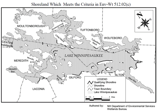
Appendix E:
Summary of Abbreviations and Acronyms
|
Term |
Meaning |
|
Agriculture
BMWPs |
“Best Management
Wetlands Practices for Agriculture” dated 2019, published by the NH
Department of Agriculture, Markets, and Food |
|
A/M BMPs |
“Wetlands Best
Management Practice Techniques For Avoidance and Minimization” dated 2019,
published by the New England Interstate Water Pollution Control Commission |
|
CPESC specialist |
Certified
Professional Erosion and Sediment Control specialist - an individual
certified by EnviroCert International, Inc.® as competent to develop and
implement erosion and sediment control practices |
|
CY |
Cubic Yard |
|
Federal
classification method |
Method
established in “Classification of Wetlands and Deepwater Habitats of the
United States”, adapted from Cowardin, Carter, Golet and LaRoe (1979), August
2013, FGDC- STD-004-2013 |
|
Federal
delineation method |
Method
established in “Wetlands Delineation Manual”, Technical Report Y-87-1, Corps
of Engineers, January 1987, and “Regional Supplement to the Corps of
Engineers Wetlands Delineation Manual:
Northcentral and Northeast Region”, Version 2.0, U.S. Army Corps of
Engineers, January 2012 |
|
Forestry BMPs |
“New Hampshire
Best Management Practices for Erosion Control on Timber Harvesting
Operations” dated 2016, published by the University of New Hampshire
Cooperative Extension |
|
HOTL |
Highest
Observable Tide Line |
|
Invasive Plant
BMPs |
“Best Management
Practices For the Control of Invasive and Noxious Plant Species” dated 2018,
published by the NHDOT |
|
Marina BMPs |
“Best Management
Practices For New Hampshire Marinas” dated 2001, published by the NHDES
Pollution Prevention Program |
|
LAC |
Local [River]
Advisory Committee |
|
LiDAR |
Light Detection
and Ranging - A surveying method that measures distance to a target by
illuminating the target with pulsed laser light and measuring the reflected
pulses with a sensor, with the differences in laser return times and
wavelengths then being used to make digital 3-D representations of the
target. |
|
LF |
Linear Foot |
|
NH Method |
“Method for
Inventorying and Evaluating Freshwater Wetlands in New Hampshire” dated 2013
and revised 2015 and 2016, available at https://nhmethod.org/ |
|
NHB |
Natural Heritage
Bureau of the NH DNCR |
|
NH DNCR |
NH Department of
Natural and Cultural Resources |
|
NHF&G |
NH Fish and Game
Department |
|
NHDOT |
NH Department of
Transportation |
|
NRCS |
Natural
Resources Conservation Service of the U.S. Department of Agriculture |
|
PBN |
Permit-by-Notification
(created in the rules) |
|
PRA |
Priority
Resource Area - a jurisdictional area that: (a)
Has documented occurrences of protected species or habitat; (b)
Is a bog; (c)
Is a floodplain wetlands contiguous to a tier 3 or higher watercourse; (d)
Is a designated prime wetland or a duly-established 100-foot buffer; (e)
Is a sand dune, tidal wetland, tidal water, or undeveloped tidal
buffer zone; or (f)
Is any combination of (a) through (e), above. |
|
Professional
engineer |
RSA 310-A:2, II.
“Professional engineer” means a person who by reason of advanced knowledge of
mathematics and the physical sciences, acquired by professional education and
practical experience, is technically and legally qualified to practice
engineering, and who is licensed by
the board or otherwise authorized by this subdivision to engage in the
practice of engineering. |
|
Routine Roadway
BMPs |
“Best Management Practices for Routine
Roadway Maintenance Activities in New Hampshire” dated 2019, published by the
NHDOT |
|
SF |
Square Foot |
|
SPN |
Statutory
Permit-by-Notification (established in RSA 482-A) |
|
Subject property |
(a)
For projects in surface water for which any kind of permit is
required, the parcel(s) of land adjacent to and associated with the area in
which the project will occur or has occurred; or (b)
For all other projects for which any kind of permit is required, the
parcel(s) of land on which the project will occur or has occurred. |
|
Trail BMPs |
“New Hampshire
Best Management Practices for Erosion Control During Trail Maintenance and
Construction” dated 2017, published by the NH DNCR |
|
US ACE |
U.S. Army Corps
of Engineers |
|
USGS |
United States
Geological Survey |
|
Utility BMPs |
“Best Management
Practices Manual, Utility Maintenance in and Adjacent to Wetlands and
Waterbodies in New Hampshire” dated 2019, published by the NH DNCR |
|
WAP |
Wildlife Action
Plan prepared and published by NHF&G |
|
Water Quality
BMPs |
Recommended
practices for minimizing or preventing the direct or indirect discharge of
sediment or other pollutants into surface waters and wetlands, including
those listed in Env-Wt 307 and the Agriculture BMPs, Forestry BMPs, Marina
BMPs, Invasive Plant BMPs, Roadway Maintenance BMPs, Trail BMPs, and Utility
BMPs, as applicable |
|
WPPT |
Wetlands Permit
Planning Tool - a GIS tool that provides access to data for planning projects
near or in jurisdictional areas, available at https://nhdeswppt.unh.edu/Html5Viewer/index.html?viewer=WPPT.gvh |